Dachong geodata
Dachong (Jiangxi) is a seat of a fourth-order administrative division; located in China in Asia/Shanghai (GMT+8) time zone. In our database, there are 1268 cities with bigger population. Compared to other cities in China, 77.3% of cities are located further ↑North; 53.4% of cities are located further ←West and 63.1% of cities have higher elevation than Dachong. Note1


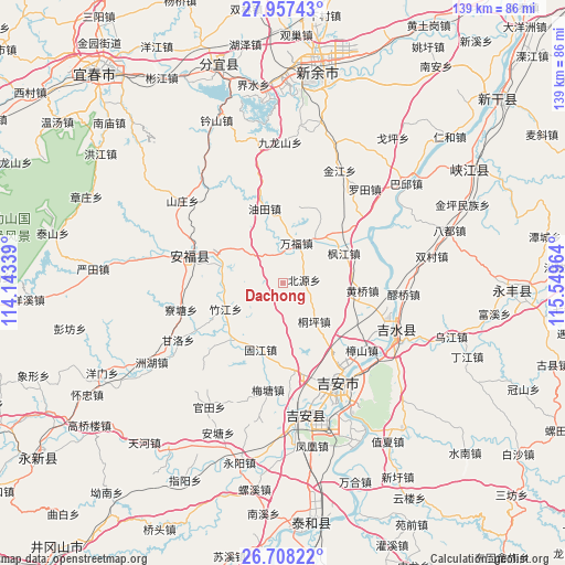
Dachong GPS coordinates[2]
27° 20' 4.488" North, 114° 50' 47.436" East
| Map corner | latitude | longitude |
|---|---|---|
| Upper-left | 27.95743°, | 114.14339° |
| Center: | 27.33458°, | 114.84651° |
| Lower-right: | 26.70822°, | 115.54964° |
| Map W x H: | 138.9×138.9 km | = 86.3×86.3mi |
| max Lat: | 53.31946° ⇑77.3% North |
| Dachong: | 27.33458° |
| min Lat: | ⇓22.7% South 18.22056° |
| min Long | Dachong | max Long |
| 75.07348° | 114.84651° | 134.28917° |
| W 53.4%⇐ | ⇒46.6% E |
Elevation
Elevation of Dachong is 82 m = 269 ft, and this is 402.8 m = 1322 ft below average elevation for this country.
| Max E: |
5622 m = 18445 ft | 63.1% |
| Avg. | 484.8 m = 1591 ft | |
| Dachong | 82 m = 269 ft | |
Min E: |
-3 m = -10 ft | 36.9% |
See also: China elevation on elevation.city.
Geographical zone
Dachong is located in North temperate zone (between Tropic of Cancer and the Arctic Circle). Distance of this Northern Tropic circle is 433.4 km =269.3 mi to South.| Distance of | km | miles | from Dachong |
|---|---|---|---|
| North Pole | 6967.7 | 4329.5 | to North |
| Arctic Circle | 4361.9 | 2710.4 | to North |
| Tropic Cancer | 433.4 | 269.3 | to South |
| Equator | 3039.3 | 1888.5 | to South |


Nearby cities:
15 places around Dachong: (largest is in red/bold)
• Changtang
19.9 km =12.4 mi,  142°
142°
• Fengjiang
16.9 km =10.5 mi,  64°
64°
• Fengtian
15.4 km =9.6 mi,  285°
285°
• Futian
13.2 km =8.2 mi,  37°
37°
• Guashe
15.2 km =9.4 mi,  304°
304°
• Gujiang
17.3 km =10.7 mi,  199°
199°
• Huangqiao
19.6 km =12.2 mi,  95°
95°
• Litian
17.9 km =11.1 mi,  220°
220°
• Pangu
19.2 km =11.9 mi, 55°
• Shangxian
11.7 km =7.3 mi,  75°
75°
• Tongping
12.2 km =7.6 mi, 140°
• Wanfu
9.3 km =5.8 mi,  22°
22°
• Xingqiao
21.8 km =13.5 mi,  172°
172°
• Youtian
20.4 km =12.7 mi,  344°
344°
• Zhujiang
15.4 km =9.6 mi,  245°
245°
Sources, notices
• [Note1] Compared only with cities in China existing in our database
• [Src1] Map data: © OpenStreetMap contributors (CC-BY-SA)
• [Src2] Other city data from geonames.org with taken over terms of usage.
• [Src3] Geographical zone / Annual Mean Temperature by Robert A. Rohde @ Wikipedia
