Wafangdian geodata
Wafangdian (Liaoning) is a populated place; located in China in Asia/Shanghai (GMT+8) time zone. With population of 250,591 people, there are 202 cities with bigger population in this country. Compared to other cities in China, 85% of cities are located further ↓South; 91.1% of cities are located further ←West and 59.2% of cities have higher elevation than Wafangdian. Note1


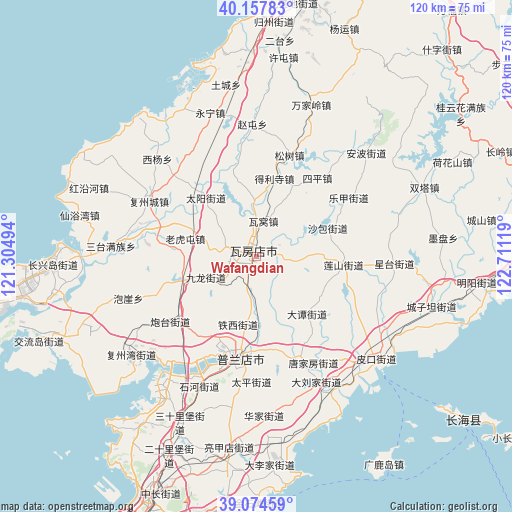
Wafangdian GPS coordinates[2]
39° 37' 5.988" North, 122° 0' 29.016" East
| Map corner | latitude | longitude |
|---|---|---|
| Upper-left | 40.15783°, | 121.30494° |
| Center: | 39.61833°, | 122.00806° |
| Lower-right: | 39.07459°, | 122.71119° |
| Map W x H: | 120.4×120.4 km | = 74.8×74.8mi |
| max Lat: | 53.31946° ⇑15% North |
| Wafangdian: | 39.61833° |
| min Lat: | ⇓85% South 18.22056° |
| min Long | Wafangdian | max Long |
| 75.07348° | 122.00806° | 134.28917° |
| W 91.1%⇐ | ⇒8.9% E |
Elevation
Elevation of Wafangdian is 103 m = 338 ft, and this is 381.8 m = 1253 ft below average elevation for this country.
| Max E: |
5622 m = 18445 ft | 59.2% |
| Avg. | 484.8 m = 1591 ft | |
| Wafangdian | 103 m = 338 ft | |
Min E: |
-3 m = -10 ft | 40.8% |
See also: Wafangdian elevation on elevation.city.
Geographical zone
Wafangdian is located in North temperate zone (between Tropic of Cancer and the Arctic Circle). Distance of this Northern Tropic circle is 1799.2 km =1118 mi to South.| Distance of | km | miles | from Wafangdian |
|---|---|---|---|
| North Pole | 5601.9 | 3480.9 | to North |
| Arctic Circle | 2996 | 1861.6 | to North |
| Tropic Cancer | 1799.2 | 1118 | to South |
| Equator | 4405.1 | 2737.2 | to South |


Nearby cities:
15 places around Wafangdian: (largest is in red/bold)
• Dachang Shandao
63.5 km =39.5 mi,  126°
126°
• Dalianwan
70.9 km =44.1 mi,  202°
202°
• Guoyuan
63.5 km =39.5 mi,  10°
10°
• Heping
59.9 km =37.2 mi,  15°
15°
• Honghai
69.8 km =43.4 mi, 7°
• Jinzhou
62.8 km =39 mi, 203°
• Jiulongdi
60.1 km =37.3 mi, 8°
• Jiuzhai
53.2 km =33.1 mi, 8°
• Mashizhai
52.7 km =32.7 mi, 6°
• Pulandian
25.1 km =15.6 mi,  188°
188°
• Shizijie
64.2 km =39.9 mi,  39°
39°
• Shuangtai
70.4 km =43.7 mi, 18°
• Xilanqi
68.3 km =42.4 mi, 9°
• Xiongyue
62.9 km =39.1 mi, 8°
• Xutun
47 km =29.2 mi, 7°
Sources, notices
• [Note1] Compared only with cities in China existing in our database
• [Src1] Map data: © OpenStreetMap contributors (CC-BY-SA)
• [Src2] Other city data from geonames.org with taken over terms of usage.
• [Src3] Geographical zone / Annual Mean Temperature by Robert A. Rohde @ Wikipedia
