Jinzhou geodata
Jinzhou (Liaoning) is a populated place; located in China in Asia/Shanghai (GMT+8) time zone. With population of 215,386 people, there are 219 cities with bigger population in this country. Compared to other cities in China, 83.2% of cities are located further ↓South; 90.6% of cities are located further ←West and 92.7% of cities have higher elevation than Jinzhou. Note1


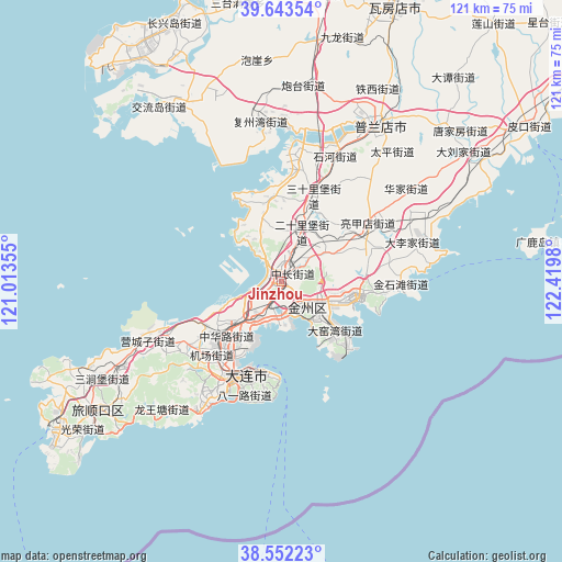
Jinzhou GPS coordinates[2]
39° 6' 0" North, 121° 43' 0.012" East
| Map corner | latitude | longitude |
|---|---|---|
| Upper-left | 39.64354°, | 121.01355° |
| Center: | 39.1°, | 121.71667° |
| Lower-right: | 38.55223°, | 122.4198° |
| Map W x H: | 121.3×121.3 km | = 75.4×75.4mi |
| max Lat: | 53.31946° ⇑16.8% North |
| Jinzhou: | 39.1° |
| min Lat: | ⇓83.2% South 18.22056° |
| min Long | Jinzhou | max Long |
| 75.07348° | 121.71667° | 134.28917° |
| W 90.6%⇐ | ⇒9.4% E |
Elevation
Elevation of Jinzhou is 8 m = 26 ft, and this is 476.8 m = 1564 ft below average elevation for this country.
| Max E: |
5622 m = 18445 ft | 92.7% |
| Avg. | 484.8 m = 1591 ft | |
| Jinzhou | 8 m = 26 ft | |
Min E: |
-3 m = -10 ft | 7.3% |
See also: Jinzhou elevation on elevation.city.
Geographical zone
Jinzhou is located in North temperate zone (between Tropic of Cancer and the Arctic Circle). Distance of this Northern Tropic circle is 1741.6 km =1082.2 mi to South.| Distance of | km | miles | from Jinzhou |
|---|---|---|---|
| North Pole | 5659.5 | 3516.6 | to North |
| Arctic Circle | 3053.7 | 1897.5 | to North |
| Tropic Cancer | 1741.6 | 1082.2 | to South |
| Equator | 4347.5 | 2701.4 | to South |


Nearby cities:
15 places around Jinzhou: (largest is in red/bold)
• Dachang Shandao
78.6 km =48.8 mi,  75°
75°
• Dalian
23.1 km =14.4 mi,  205°
205°
• Dalianwan
8.2 km =5.1 mi,  193°
193°
• Guoyuan
125.5 km =78 mi,  16°
16°
• Heping
122.5 km =76.1 mi, 19°
• Jiulongdi
121.8 km =75.7 mi, 15°
• Jiuzhai
115.1 km =71.5 mi, 16°
• Lüshun
51.3 km =31.9 mi,  229°
229°
• Mashizhai
114.3 km =71 mi, 15°
• Pulandian
39.3 km =24.4 mi,  33°
33°
• Shizijie
125.8 km =78.2 mi, 31°
• Wafangdian
62.8 km =39 mi, 23°
• Xiongyue
124.7 km =77.5 mi, 16°
• Xutun
108.7 km =67.5 mi, 16°
• Zhuanghe
128.3 km =79.7 mi,  58°
58°
Sources, notices
• [Note1] Compared only with cities in China existing in our database
• [Src1] Map data: © OpenStreetMap contributors (CC-BY-SA)
• [Src2] Other city data from geonames.org with taken over terms of usage.
• [Src3] Geographical zone / Annual Mean Temperature by Robert A. Rohde @ Wikipedia
