Tuojiang geodata
Tuojiang (Hunan) is a seat of a third-order administrative division; located in China in Asia/Shanghai (GMT+8) time zone. In our database, there are 1268 cities with bigger population. Compared to other cities in China, 74.3% of cities are located further ↑North; 73.5% of cities are located further →East and 68.1% of cities have lower elevation than Tuojiang. Note1


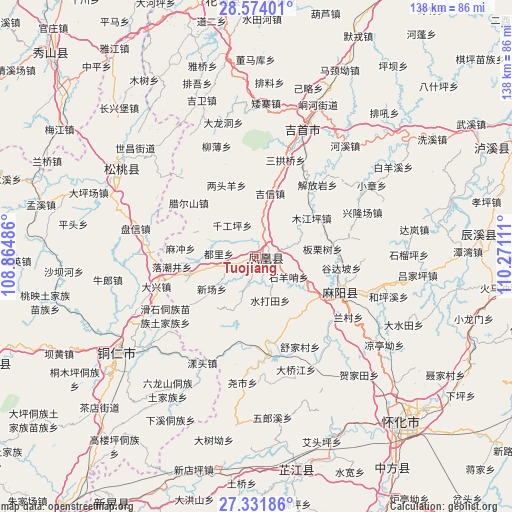
Tuojiang GPS coordinates[2]
27° 57' 16.992" North, 109° 34' 4.728" East
| Map corner | latitude | longitude |
|---|---|---|
| Upper-left | 28.57401°, | 108.86486° |
| Center: | 27.95472°, | 109.56798° |
| Lower-right: | 27.33186°, | 110.27111° |
| Map W x H: | 138.1×138.1 km | = 85.8×85.8mi |
| max Lat: | 53.31946° ⇑74.3% North |
| Tuojiang: | 27.95472° |
| min Lat: | ⇓25.7% South 18.22056° |
| min Long | Tuojiang | max Long |
| 75.07348° | 109.56798° | 134.28917° |
| W 26.5%⇐ | ⇒73.5% E |
Elevation
Elevation of Tuojiang is 378 m = 1240 ft, and this is 106.8 m = 350 ft below average elevation for this country.
| Max E: |
5622 m = 18445 ft | 31.9% |
| Avg. | 484.8 m = 1591 ft | |
| Tuojiang | 378 m = 1240 ft | |
Min E: |
-3 m = -10 ft | 68.1% |
See also: China elevation on elevation.city.
Geographical zone
Tuojiang is located in North temperate zone (between Tropic of Cancer and the Arctic Circle). Distance of this Northern Tropic circle is 502.4 km =312.2 mi to South.| Distance of | km | miles | from Tuojiang |
|---|---|---|---|
| North Pole | 6898.8 | 4286.7 | to North |
| Arctic Circle | 4292.9 | 2667.5 | to North |
| Tropic Cancer | 502.4 | 312.2 | to South |
| Equator | 3108.3 | 1931.4 | to South |


Nearby cities:
15 places around Tuojiang: (largest is in red/bold)
• Banpan
17.3 km =10.7 mi,  288°
288°
• Chatian
25.5 km =15.8 mi,  228°
228°
• Datian
19.7 km =12.2 mi,  2°
2°
• Fenghuang
3.8 km =2.4 mi,  124°
124°
• Gaocun
23 km =14.3 mi,  112°
112°
• Huoluping
21.7 km =13.5 mi,  345°
345°
• Jixin
17.4 km =10.8 mi,  12°
12°
• La’ershan
23.3 km =14.5 mi,  308°
308°
• Liangtouyang
20.8 km =12.9 mi,  337°
337°
• Mujiangping
18.3 km =11.4 mi,  54°
54°
• Qiangongping
10.6 km =6.6 mi,  322°
322°
• Qiaoxikou
15 km =9.3 mi, 48°
• Shanjiang
14.5 km =9 mi, 314°
• Shuidatian
12 km =7.5 mi,  162°
162°
• Yanmen
20.2 km =12.6 mi, 123°
Sources, notices
• [Note1] Compared only with cities in China existing in our database
• [Src1] Map data: © OpenStreetMap contributors (CC-BY-SA)
• [Src2] Other city data from geonames.org with taken over terms of usage.
• [Src3] Geographical zone / Annual Mean Temperature by Robert A. Rohde @ Wikipedia
