Tongguan geodata
Tongguan (Hunan) is a seat of a fourth-order administrative division; located in China in Asia/Shanghai (GMT+8) time zone. In our database, there are 1268 cities with bigger population. Compared to other cities in China, 70.1% of cities are located further ↑North; 58.6% of cities are located further →East and 68.9% of cities have higher elevation than Tongguan. Note1


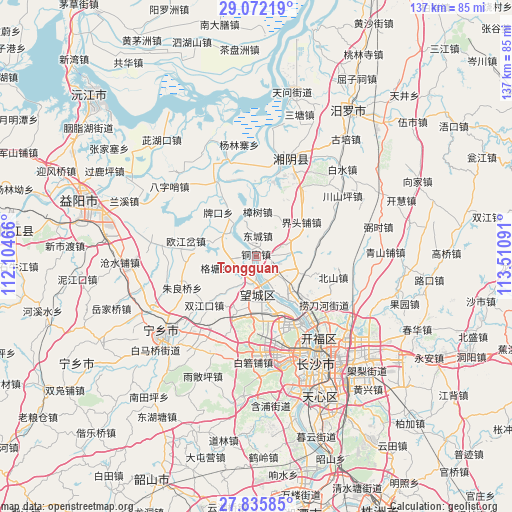
Tongguan GPS coordinates[2]
28° 27' 20.988" North, 112° 48' 28.008" East
| Map corner | latitude | longitude |
|---|---|---|
| Upper-left | 29.07219°, | 112.10466° |
| Center: | 28.45583°, | 112.80778° |
| Lower-right: | 27.83585°, | 113.51091° |
| Map W x H: | 137.5×137.5 km | = 85.4×85.4mi |
| max Lat: | 53.31946° ⇑70.1% North |
| Tongguan: | 28.45583° |
| min Lat: | ⇓29.9% South 18.22056° |
| min Long | Tongguan | max Long |
| 75.07348° | 112.80778° | 134.28917° |
| W 41.4%⇐ | ⇒58.6% E |
Elevation
Elevation of Tongguan is 56 m = 184 ft, and this is 428.8 m = 1407 ft below average elevation for this country.
| Max E: |
5622 m = 18445 ft | 68.9% |
| Avg. | 484.8 m = 1591 ft | |
| Tongguan | 56 m = 184 ft | |
Min E: |
-3 m = -10 ft | 31.1% |
See also: China elevation on elevation.city.
Geographical zone
Tongguan is located in North temperate zone (between Tropic of Cancer and the Arctic Circle). Distance of this Northern Tropic circle is 558.1 km =346.8 mi to South.| Distance of | km | miles | from Tongguan |
|---|---|---|---|
| North Pole | 6843.1 | 4252.1 | to North |
| Arctic Circle | 4237.2 | 2632.9 | to North |
| Tropic Cancer | 558.1 | 346.8 | to South |
| Equator | 3164 | 1966 | to South |


Nearby cities:
15 places around Tongguan: (largest is in red/bold)
• Bairuopu
28.5 km =17.7 mi,  181°
181°
• Bazishao
29.9 km =18.6 mi,  307°
307°
• Beishan
19.3 km =12 mi,  108°
108°
• Changsha
32.7 km =20.3 mi,  150°
150°
• Chating
12.5 km =7.8 mi,  68°
68°
• Furong Beilu
29.6 km =18.4 mi, 145°
• Gaotangling
10 km =6.2 mi,  174°
174°
• Oujiangcha
20.8 km =12.9 mi,  273°
273°
• Qiaokou
8.9 km =5.5 mi, 305°
• Qiaoyi
11.8 km =7.3 mi, 111°
• Wangyue
26.7 km =16.6 mi,  156°
156°
• Wenxing
26.1 km =16.2 mi,  15°
15°
• Xinquansi
22 km =13.7 mi,  330°
330°
• Yuhua
19.9 km =12.4 mi,  45°
45°
• Zhangshu
11.9 km =7.4 mi,  1°
1°
Sources, notices
• [Note1] Compared only with cities in China existing in our database
• [Src1] Map data: © OpenStreetMap contributors (CC-BY-SA)
• [Src2] Other city data from geonames.org with taken over terms of usage.
• [Src3] Geographical zone / Annual Mean Temperature by Robert A. Rohde @ Wikipedia
