Xinquansi geodata
Xinquansi (Hunan) is a seat of a fourth-order administrative division; located in China in Asia/Shanghai (GMT+8) time zone. In our database, there are 1268 cities with bigger population. Compared to other cities in China, 68.6% of cities are located further ↑North; 59.1% of cities are located further →East and 78.8% of cities have higher elevation than Xinquansi. Note1


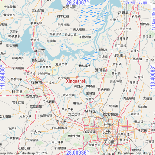
Xinquansi GPS coordinates[2]
28° 37' 41.988" North, 112° 41' 51" East
| Map corner | latitude | longitude |
|---|---|---|
| Upper-left | 29.24367°, | 111.99438° |
| Center: | 28.62833°, | 112.6975° |
| Lower-right: | 28.00936°, | 113.40063° |
| Map W x H: | 137.2×137.2 km | = 85.3×85.3mi |
| max Lat: | 53.31946° ⇑68.6% North |
| Xinquansi: | 28.62833° |
| min Lat: | ⇓31.4% South 18.22056° |
| min Long | Xinquansi | max Long |
| 75.07348° | 112.6975° | 134.28917° |
| W 40.9%⇐ | ⇒59.1% E |
Elevation
Elevation of Xinquansi is 29 m = 95 ft, and this is 455.8 m = 1495 ft below average elevation for this country.
| Max E: |
5622 m = 18445 ft | 78.8% |
| Avg. | 484.8 m = 1591 ft | |
| Xinquansi | 29 m = 95 ft | |
Min E: |
-3 m = -10 ft | 21.2% |
See also: China elevation on elevation.city.
Geographical zone
Xinquansi is located in North temperate zone (between Tropic of Cancer and the Arctic Circle). Distance of this Northern Tropic circle is 577.3 km =358.7 mi to South.| Distance of | km | miles | from Xinquansi |
|---|---|---|---|
| North Pole | 6823.9 | 4240.2 | to North |
| Arctic Circle | 4218 | 2620.9 | to North |
| Tropic Cancer | 577.3 | 358.7 | to South |
| Equator | 3183.2 | 1977.9 | to South |


Nearby cities:
15 places around Xinquansi: (largest is in red/bold)
• Bazishao
12.9 km =8 mi,  266°
266°
• Cangshuipu
33 km =20.5 mi,  230°
230°
• Chating
26.6 km =16.5 mi,  123°
123°
• Cihukou
18.4 km =11.4 mi,  309°
309°
• Dongtang
31.3 km =19.4 mi,  57°
57°
• Gaotangling
31.3 km =19.4 mi,  158°
158°
• Oujiangcha
20.3 km =12.6 mi,  209°
209°
• Qiaokou
14.4 km =8.9 mi,  165°
165°
• Qiaoyi
32 km =19.9 mi,  137°
137°
• Qingtan
29.4 km =18.3 mi,  29°
29°
• Tongguan
22 km =13.7 mi,  150°
150°
• Wenxing
18.7 km =11.6 mi,  71°
71°
• Yanglinzhai
15.5 km =9.6 mi,  6°
6°
• Yuhua
25.5 km =15.8 mi,  101°
101°
• Zhangshu
13.3 km =8.3 mi, 123°
Sources, notices
• [Note1] Compared only with cities in China existing in our database
• [Src1] Map data: © OpenStreetMap contributors (CC-BY-SA)
• [Src2] Other city data from geonames.org with taken over terms of usage.
• [Src3] Geographical zone / Annual Mean Temperature by Robert A. Rohde @ Wikipedia
