Qiaokou geodata
Qiaokou (Hunan) is a seat of a fourth-order administrative division; located in China in Asia/Shanghai (GMT+8) time zone. In our database, there are 1268 cities with bigger population. Compared to other cities in China, 69.7% of cities are located further ↑North; 58.9% of cities are located further →East and 78.3% of cities have higher elevation than Qiaokou. Note1


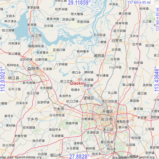
Qiaokou GPS coordinates[2]
28° 30' 9" North, 112° 43' 59.988" East
| Map corner | latitude | longitude |
|---|---|---|
| Upper-left | 29.11859°, | 112.03021° |
| Center: | 28.5025°, | 112.73333° |
| Lower-right: | 27.8828°, | 113.43646° |
| Map W x H: | 137.4×137.4 km | = 85.4×85.4mi |
| max Lat: | 53.31946° ⇑69.7% North |
| Qiaokou: | 28.5025° |
| min Lat: | ⇓30.3% South 18.22056° |
| min Long | Qiaokou | max Long |
| 75.07348° | 112.73333° | 134.28917° |
| W 41.1%⇐ | ⇒58.9% E |
Elevation
Elevation of Qiaokou is 30 m = 98 ft, and this is 454.8 m = 1492 ft below average elevation for this country.
| Max E: |
5622 m = 18445 ft | 78.3% |
| Avg. | 484.8 m = 1591 ft | |
| Qiaokou | 30 m = 98 ft | |
Min E: |
-3 m = -10 ft | 21.7% |
See also: China elevation on elevation.city.
Geographical zone
Qiaokou is located in North temperate zone (between Tropic of Cancer and the Arctic Circle). Distance of this Northern Tropic circle is 563.3 km =350 mi to South.| Distance of | km | miles | from Qiaokou |
|---|---|---|---|
| North Pole | 6837.9 | 4248.9 | to North |
| Arctic Circle | 4232 | 2629.6 | to North |
| Tropic Cancer | 563.3 | 350 | to South |
| Equator | 3169.2 | 1969.2 | to South |


Nearby cities:
15 places around Qiaokou: (largest is in red/bold)
• Bazishao
21 km =13 mi,  308°
308°
• Beishan
27.9 km =17.3 mi,  113°
113°
• Cangshuipu
29.9 km =18.6 mi,  256°
256°
• Chating
18.8 km =11.7 mi,  91°
91°
• Cihukou
31.2 km =19.4 mi,  325°
325°
• Gaotangling
17.2 km =10.7 mi,  151°
151°
• Oujiangcha
13.9 km =8.6 mi,  254°
254°
• Qiaoyi
20.6 km =12.8 mi,  117°
117°
• Tongguan
8.9 km =5.5 mi,  125°
125°
• Wenxing
24.5 km =15.2 mi,  35°
35°
• Xinquansi
14.4 km =8.9 mi,  345°
345°
• Yanglinzhai
29.4 km =18.3 mi,  356°
356°
• Yuhua
23.2 km =14.4 mi,  67°
67°
• Yutan
32 km =19.9 mi,  211°
211°
• Zhangshu
10.2 km =6.3 mi,  48°
48°
Sources, notices
• [Note1] Compared only with cities in China existing in our database
• [Src1] Map data: © OpenStreetMap contributors (CC-BY-SA)
• [Src2] Other city data from geonames.org with taken over terms of usage.
• [Src3] Geographical zone / Annual Mean Temperature by Robert A. Rohde @ Wikipedia
