Qiaoyi geodata
Qiaoyi (Hunan) is a seat of a fourth-order administrative division; located in China in Asia/Shanghai (GMT+8) time zone. In our database, there are 1268 cities with bigger population. Compared to other cities in China, 70.4% of cities are located further ↑North; 58% of cities are located further →East and 73.7% of cities have higher elevation than Qiaoyi. Note1


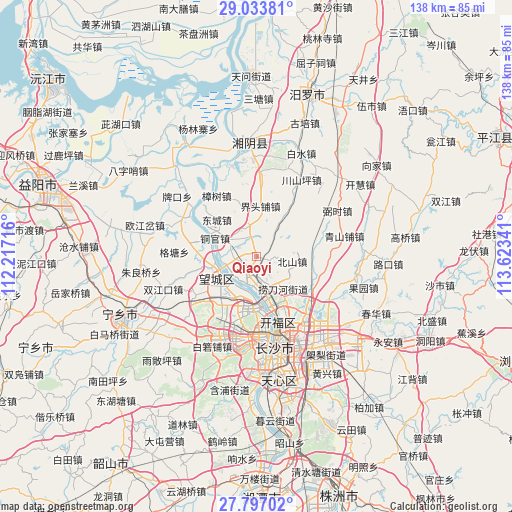
Qiaoyi GPS coordinates[2]
28° 25' 1.992" North, 112° 55' 13.008" East
| Map corner | latitude | longitude |
|---|---|---|
| Upper-left | 29.03381°, | 112.21716° |
| Center: | 28.41722°, | 112.92028° |
| Lower-right: | 27.79702°, | 113.62341° |
| Map W x H: | 137.5×137.5 km | = 85.4×85.4mi |
| max Lat: | 53.31946° ⇑70.4% North |
| Qiaoyi: | 28.41722° |
| min Lat: | ⇓29.6% South 18.22056° |
| min Long | Qiaoyi | max Long |
| 75.07348° | 112.92028° | 134.28917° |
| W 42%⇐ | ⇒58% E |
Elevation
Elevation of Qiaoyi is 40 m = 131 ft, and this is 444.8 m = 1459 ft below average elevation for this country.
| Max E: |
5622 m = 18445 ft | 73.7% |
| Avg. | 484.8 m = 1591 ft | |
| Qiaoyi | 40 m = 131 ft | |
Min E: |
-3 m = -10 ft | 26.3% |
See also: China elevation on elevation.city.
Geographical zone
Qiaoyi is located in North temperate zone (between Tropic of Cancer and the Arctic Circle). Distance of this Northern Tropic circle is 553.8 km =344.1 mi to South.| Distance of | km | miles | from Qiaoyi |
|---|---|---|---|
| North Pole | 6847.4 | 4254.8 | to North |
| Arctic Circle | 4241.5 | 2635.5 | to North |
| Tropic Cancer | 553.8 | 344.1 | to South |
| Equator | 3159.7 | 1963.3 | to South |


Nearby cities:
15 places around Qiaoyi: (largest is in red/bold)
• Bairuopu
26.9 km =16.7 mi,  205°
205°
• Baishui
30.1 km =18.7 mi,  26°
26°
• Beishan
7.5 km =4.7 mi,  103°
103°
• Changsha
24.8 km =15.4 mi,  168°
168°
• Chating
8.9 km =5.5 mi,  3°
3°
• Dongtundu
28.2 km =17.5 mi,  157°
157°
• Furong Beilu
20.9 km =13 mi, 163°
• Gaotangling
11.6 km =7.2 mi,  240°
240°
• Qiaokou
20.6 km =12.8 mi,  297°
297°
• Tongguan
11.8 km =7.3 mi,  291°
291°
• Wangyue
20.2 km =12.6 mi,  180°
180°
• Wenxing
29.7 km =18.5 mi,  352°
352°
• Xingsha
25.7 km =16 mi,  140°
140°
• Yuhua
18.5 km =11.5 mi,  10°
10°
• Zhangshu
19.4 km =12.1 mi,  326°
326°
Sources, notices
• [Note1] Compared only with cities in China existing in our database
• [Src1] Map data: © OpenStreetMap contributors (CC-BY-SA)
• [Src2] Other city data from geonames.org with taken over terms of usage.
• [Src3] Geographical zone / Annual Mean Temperature by Robert A. Rohde @ Wikipedia
