Tonggu geodata
Tonggu (Guizhou) is a populated place; located in China in Asia/Shanghai (GMT+8) time zone. With population of 1,158 people, there are 1144 cities with bigger population in this country. Compared to other cities in China, 80.2% of cities are located further ↑North; 74.8% of cities are located further →East and 71.3% of cities have lower elevation than Tonggu. Note1


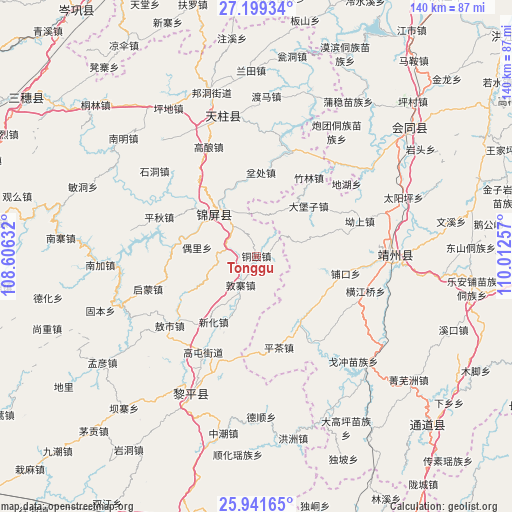
Tonggu GPS coordinates[2]
26° 34' 19.992" North, 109° 18' 33.984" East
| Map corner | latitude | longitude |
|---|---|---|
| Upper-left | 27.19934°, | 108.60632° |
| Center: | 26.57222°, | 109.30944° |
| Lower-right: | 25.94165°, | 110.01257° |
| Map W x H: | 139.8×139.8 km | = 86.9×86.9mi |
| max Lat: | 53.31946° ⇑80.2% North |
| Tonggu: | 26.57222° |
| min Lat: | ⇓19.8% South 18.22056° |
| min Long | Tonggu | max Long |
| 75.07348° | 109.30944° | 134.28917° |
| W 25.2%⇐ | ⇒74.8% E |
Elevation
Elevation of Tonggu is 436 m = 1430 ft, and this is 48.8 m = 160 ft below average elevation for this country.
| Max E: |
5622 m = 18445 ft | 28.7% |
| Avg. | 484.8 m = 1591 ft | |
| Tonggu | 436 m = 1430 ft | |
Min E: |
-3 m = -10 ft | 71.3% |
See also: China elevation on elevation.city.
Geographical zone
Tonggu is located in North temperate zone (between Tropic of Cancer and the Arctic Circle). Distance of this Northern Tropic circle is 348.6 km =216.6 mi to South.| Distance of | km | miles | from Tonggu |
|---|---|---|---|
| North Pole | 7052.5 | 4382.2 | to North |
| Arctic Circle | 4446.6 | 2763 | to North |
| Tropic Cancer | 348.6 | 216.6 | to South |
| Equator | 2954.6 | 1835.9 | to South |


Nearby cities:
15 places around Tonggu: (largest is in red/bold)
• Aoshi
30.4 km =18.9 mi,  231°
231°
• Benchu
22.2 km =13.8 mi,  355°
355°
• Dabaozi
19.4 km =12.1 mi,  45°
45°
• Dunzhai
8.9 km =5.5 mi,  208°
208°
• Gaoniang
32.7 km =20.3 mi,  336°
336°
• Guangping
39.3 km =24.4 mi, 52°
• Longlisuo
27.1 km =16.8 mi, 229°
• Maoping
20.3 km =12.6 mi,  334°
334°
• Ouyang
19.4 km =12.1 mi, 208°
• Pukou
25.1 km =15.6 mi,  102°
102°
• Qimeng
32.3 km =20.1 mi,  252°
252°
• Quyang
32.7 km =20.3 mi,  89°
89°
• Runsong
39.3 km =24.4 mi, 327°
• Sanjiang
16 km =9.9 mi,  315°
315°
• Tanxi
30.6 km =19 mi,  200°
200°
Sources, notices
• [Note1] Compared only with cities in China existing in our database
• [Src1] Map data: © OpenStreetMap contributors (CC-BY-SA)
• [Src2] Other city data from geonames.org with taken over terms of usage.
• [Src3] Geographical zone / Annual Mean Temperature by Robert A. Rohde @ Wikipedia
