Quyang geodata
Quyang (Hunan) is a seat of a third-order administrative division; located in China in Asia/Shanghai (GMT+8) time zone. In our database, there are 1268 cities with bigger population. Compared to other cities in China, 80.2% of cities are located further ↑North; 73.1% of cities are located further →East and 71.5% of cities have lower elevation than Quyang. Note1


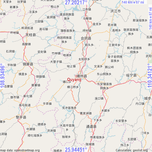
Quyang GPS coordinates[2]
26° 34' 30.252" North, 109° 38' 17.088" East
| Map corner | latitude | longitude |
|---|---|---|
| Upper-left | 27.20217°, | 108.93496° |
| Center: | 26.57507°, | 109.63808° |
| Lower-right: | 25.94451°, | 110.34121° |
| Map W x H: | 139.8×139.8 km | = 86.9×86.9mi |
| max Lat: | 53.31946° ⇑80.2% North |
| Quyang: | 26.57507° |
| min Lat: | ⇓19.8% South 18.22056° |
| min Long | Quyang | max Long |
| 75.07348° | 109.63808° | 134.28917° |
| W 26.9%⇐ | ⇒73.1% E |
Elevation
Elevation of Quyang is 440 m = 1444 ft, and this is 44.8 m = 147 ft below average elevation for this country.
| Max E: |
5622 m = 18445 ft | 28.5% |
| Avg. | 484.8 m = 1591 ft | |
| Quyang | 440 m = 1444 ft | |
Min E: |
-3 m = -10 ft | 71.5% |
See also: China elevation on elevation.city.
Geographical zone
Quyang is located in North temperate zone (between Tropic of Cancer and the Arctic Circle). Distance of this Northern Tropic circle is 349 km =216.9 mi to South.| Distance of | km | miles | from Quyang |
|---|---|---|---|
| North Pole | 7052.2 | 4382 | to North |
| Arctic Circle | 4446.3 | 2762.8 | to North |
| Tropic Cancer | 349 | 216.9 | to South |
| Equator | 2954.9 | 1836.1 | to South |


Nearby cities:
15 places around Quyang: (largest is in red/bold)
• Benchu
40.8 km =25.4 mi,  302°
302°
• Boyang
42.1 km =26.2 mi,  196°
196°
• Dabaozi
23.2 km =14.4 mi,  305°
305°
• Diyangping
33.8 km =21 mi,  185°
185°
• Dongshan Dongzuxiang
25.8 km =16 mi,  85°
85°
• Dunzhai
37.8 km =23.5 mi,  257°
257°
• Guangping
23.6 km =14.7 mi,  356°
356°
• Le’anpu Miaozudongzuxiang
27.8 km =17.3 mi,  108°
108°
• Lianshan
26.2 km =16.3 mi,  14°
14°
• Lincheng
32.8 km =20.4 mi,  4°
4°
• Pukou
10.1 km =6.3 mi,  234°
234°
• Tonggu
32.7 km =20.3 mi,  269°
269°
• Xianxi
26.7 km =16.6 mi,  178°
178°
• Xinglong
41.6 km =25.8 mi,  332°
332°
• Zhaishi Miaozu Dongzuxiang
41.3 km =25.7 mi,  101°
101°
Sources, notices
• [Note1] Compared only with cities in China existing in our database
• [Src1] Map data: © OpenStreetMap contributors (CC-BY-SA)
• [Src2] Other city data from geonames.org with taken over terms of usage.
• [Src3] Geographical zone / Annual Mean Temperature by Robert A. Rohde @ Wikipedia
