Dabaozi geodata
Dabaozi (Hunan) is a populated place; located in China in Asia/Shanghai (GMT+8) time zone. With population of 1,440 people, there are 1102 cities with bigger population in this country. Compared to other cities in China, 79.7% of cities are located further ↑North; 74.2% of cities are located further →East and 69.7% of cities have lower elevation than Dabaozi. Note1


Dabaozi GPS coordinates[2]
26° 41' 44.016" North, 109° 26' 52.008" East
| Map corner | latitude | longitude |
|---|---|---|
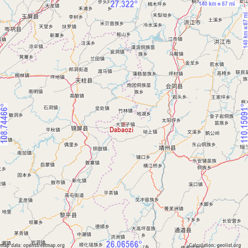
| Upper-left | 27.322°, | 108.74466° |
| Center: | 26.69556°, | 109.44778° |
| Lower-right: | 26.06566°, | 110.15091° |
| Map W x H: | 139.7×139.7 km | = 86.8×86.8mi |
| max Lat: | 53.31946° ⇑79.7% North |
| Dabaozi: | 26.69556° |
| min Lat: | ⇓20.3% South 18.22056° |
| min Long | Dabaozi | max Long |
| 75.07348° | 109.44778° | 134.28917° |
| W 25.8%⇐ | ⇒74.2% E |
Elevation
Elevation of Dabaozi is 404 m = 1325 ft, and this is 80.8 m = 265 ft below average elevation for this country.
| Max E: |
5622 m = 18445 ft | 30.3% |
| Avg. | 484.8 m = 1591 ft | |
| Dabaozi | 404 m = 1325 ft | |
Min E: |
-3 m = -10 ft | 69.7% |
See also: China elevation on elevation.city.
Geographical zone
Dabaozi is located in North temperate zone (between Tropic of Cancer and the Arctic Circle). Distance of this Northern Tropic circle is 362.3 km =225.1 mi to South.| Distance of | km | miles | from Dabaozi |
|---|---|---|---|
| North Pole | 7038.8 | 4373.7 | to North |
| Arctic Circle | 4432.9 | 2754.5 | to North |
| Tropic Cancer | 362.3 | 225.1 | to South |
| Equator | 2968.3 | 1844.4 | to South |


Nearby cities:
15 places around Dabaozi: (largest is in red/bold)
• Baishi
30.9 km =19.2 mi,  359°
359°
• Benchu
17.7 km =11 mi,  298°
298°
• Dunzhai
28 km =17.4 mi,  219°
219°
• Gaoniang
31.3 km =19.4 mi, 301°
• Guangping
20.2 km =12.6 mi,  59°
59°
• Jiangdong
32.4 km =20.1 mi,  1°
1°
• Lianshan
27.9 km =17.3 mi, 64°
• Lincheng
28.8 km =17.9 mi,  47°
47°
• Maoping
23 km =14.3 mi,  281°
281°
• Ouyang
38.4 km =23.9 mi, 216°
• Pukou
22.1 km =13.7 mi,  150°
150°
• Quyang
23.2 km =14.4 mi,  125°
125°
• Sanjiang
25.1 km =15.6 mi,  264°
264°
• Tonggu
19.4 km =12.1 mi,  225°
225°
• Xinglong
23.5 km =14.6 mi, 359°
Sources, notices
• [Note1] Compared only with cities in China existing in our database
• [Src1] Map data: © OpenStreetMap contributors (CC-BY-SA)
• [Src2] Other city data from geonames.org with taken over terms of usage.
• [Src3] Geographical zone / Annual Mean Temperature by Robert A. Rohde @ Wikipedia
