Tongfang geodata
Tongfang (Fujian) is a seat of a fourth-order administrative division; located in China in Asia/Shanghai (GMT+8) time zone. In our database, there are 1268 cities with bigger population. Compared to other cities in China, 83.1% of cities are located further ↑North; 63.4% of cities are located further ←West and 75.9% of cities have lower elevation than Tongfang. Note1


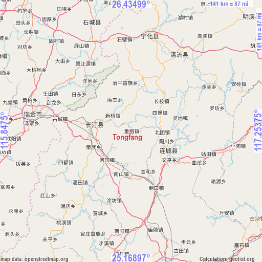
Tongfang GPS coordinates[2]
25° 48' 13.212" North, 116° 33' 2.232" East
| Map corner | latitude | longitude |
|---|---|---|
| Upper-left | 26.43499°, | 115.8475° |
| Center: | 25.80367°, | 116.55062° |
| Lower-right: | 25.16897°, | 117.25375° |
| Map W x H: | 140.8×140.8 km | = 87.5×87.5mi |
| max Lat: | 53.31946° ⇑83.1% North |
| Tongfang: | 25.80367° |
| min Lat: | ⇓16.9% South 18.22056° |
| min Long | Tongfang | max Long |
| 75.07348° | 116.55062° | 134.28917° |
| W 63.4%⇐ | ⇒36.6% E |
Elevation
Elevation of Tongfang is 544 m = 1785 ft, and this is 59.2 m = 194 ft above average elevation for this country.
| Max E: |
5622 m = 18445 ft | 24.1% |
| Tongfang | 544 m 1785 ft | |
| Avg. | 484.8 m = 1591 ft | |
Min E: |
-3 m = -10 ft | 75.9% |
See also: China elevation on elevation.city.
Geographical zone
Tongfang is located in North temperate zone (between Tropic of Cancer and the Arctic Circle). Distance of this Northern Tropic circle is 263.2 km =163.5 mi to South.| Distance of | km | miles | from Tongfang |
|---|---|---|---|
| North Pole | 7138 | 4435.3 | to North |
| Arctic Circle | 4532.1 | 2816.1 | to North |
| Tropic Cancer | 263.2 | 163.5 | to South |
| Equator | 2869.1 | 1782.8 | to South |


Nearby cities:
15 places around Tongfang: (largest is in red/bold)
• Anjie
19.3 km =12 mi,  332°
332°
• Beituan
16.6 km =10.3 mi,  91°
91°
• Cewu
22 km =13.7 mi,  247°
247°
• Datong
19.7 km =12.2 mi,  282°
282°
• Gechuan
19.7 km =12.2 mi,  105°
105°
• Guanqian
14.8 km =9.2 mi,  357°
357°
• Hetian
20.4 km =12.7 mi,  221°
221°
• Lianfeng
20.4 km =12.7 mi,  122°
122°
• Luofang
14.6 km =9.1 mi, 113°
• Sibao
18.6 km =11.6 mi,  56°
56°
• Tiechang
21.1 km =13.1 mi,  312°
312°
• Tingzhou
22.3 km =13.9 mi, 277°
• Xiaoxi
23 km =14.3 mi,  44°
44°
• Xinqiao
13.1 km =8.1 mi, 310°
• Xuanhe
23.3 km =14.5 mi,  157°
157°
Sources, notices
• [Note1] Compared only with cities in China existing in our database
• [Src1] Map data: © OpenStreetMap contributors (CC-BY-SA)
• [Src2] Other city data from geonames.org with taken over terms of usage.
• [Src3] Geographical zone / Annual Mean Temperature by Robert A. Rohde @ Wikipedia
