Hetian geodata
Hetian (Fujian) is a seat of a fourth-order administrative division; located in China in Asia/Shanghai (GMT+8) time zone. In our database, there are 1268 cities with bigger population. Compared to other cities in China, 83.6% of cities are located further ↑North; 62.5% of cities are located further ←West and 61.8% of cities have lower elevation than Hetian. Note1


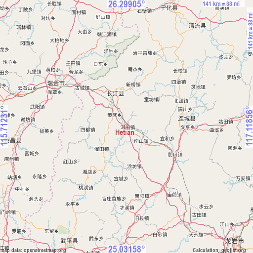
Hetian GPS coordinates[2]
25° 40' 1.2" North, 116° 24' 55.548" East
| Map corner | latitude | longitude |
|---|---|---|
| Upper-left | 26.29905°, | 115.71231° |
| Center: | 25.667°, | 116.41543° |
| Lower-right: | 25.03158°, | 117.11856° |
| Map W x H: | 140.9×140.9 km | = 87.6×87.6mi |
| max Lat: | 53.31946° ⇑83.6% North |
| Hetian: | 25.667° |
| min Lat: | ⇓16.4% South 18.22056° |
| min Long | Hetian | max Long |
| 75.07348° | 116.41543° | 134.28917° |
| W 62.5%⇐ | ⇒37.5% E |
Elevation
Elevation of Hetian is 280 m = 919 ft, and this is 204.8 m = 672 ft below average elevation for this country.
| Max E: |
5622 m = 18445 ft | 38.2% |
| Avg. | 484.8 m = 1591 ft | |
| Hetian | 280 m = 919 ft | |
Min E: |
-3 m = -10 ft | 61.8% |
See also: China elevation on elevation.city.
Geographical zone
Hetian is located in North temperate zone (between Tropic of Cancer and the Arctic Circle). Distance of this Northern Tropic circle is 248 km =154.1 mi to South.| Distance of | km | miles | from Hetian |
|---|---|---|---|
| North Pole | 7153.2 | 4444.8 | to North |
| Arctic Circle | 4547.3 | 2825.6 | to North |
| Tropic Cancer | 248 | 154.1 | to South |
| Equator | 2853.9 | 1773.3 | to South |


Nearby cities:
15 places around Hetian: (largest is in red/bold)
• Cewu
9.6 km =6 mi,  315°
315°
• Datong
20.3 km =12.6 mi,  343°
343°
• Luofang
28.4 km =17.6 mi,  70°
70°
• Nanshan
11.1 km =6.9 mi,  133°
133°
• Pengkou
30.9 km =19.2 mi,  119°
119°
• Sanzhou
9.1 km =5.7 mi,  204°
204°
• Sidu
21.8 km =13.5 mi,  266°
266°
• Tiechang
29.5 km =18.3 mi,  356°
356°
• Tingzhou
19.9 km =12.4 mi,  334°
334°
• Tongfang
20.4 km =12.7 mi,  41°
41°
• Tufang
22.2 km =13.8 mi,  168°
168°
• Xinqiao
24.1 km =15 mi,  8°
8°
• Xuancheng
28.8 km =17.9 mi,  186°
186°
• Xuanhe
23.5 km =14.6 mi,  105°
105°
• Zhuotian
18.5 km =11.5 mi,  229°
229°
Sources, notices
• [Note1] Compared only with cities in China existing in our database
• [Src1] Map data: © OpenStreetMap contributors (CC-BY-SA)
• [Src2] Other city data from geonames.org with taken over terms of usage.
• [Src3] Geographical zone / Annual Mean Temperature by Robert A. Rohde @ Wikipedia
