Xuanhe geodata
Xuanhe (Fujian) is a seat of a fourth-order administrative division; located in China in Asia/Shanghai (GMT+8) time zone. In our database, there are 1268 cities with bigger population. Compared to other cities in China, 83.8% of cities are located further ↑North; 63.9% of cities are located further ←West and 67.6% of cities have lower elevation than Xuanhe. Note1


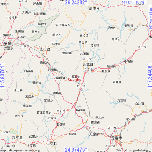
Xuanhe GPS coordinates[2]
25° 36' 37.692" North, 116° 38' 27.348" East
| Map corner | latitude | longitude |
|---|---|---|
| Upper-left | 26.24282°, | 115.93781° |
| Center: | 25.61047°, | 116.64093° |
| Lower-right: | 24.97475°, | 117.34406° |
| Map W x H: | 141×141 km | = 87.6×87.6mi |
| max Lat: | 53.31946° ⇑83.8% North |
| Xuanhe: | 25.61047° |
| min Lat: | ⇓16.2% South 18.22056° |
| min Long | Xuanhe | max Long |
| 75.07348° | 116.64093° | 134.28917° |
| W 63.9%⇐ | ⇒36.1% E |
Elevation
Elevation of Xuanhe is 370 m = 1214 ft, and this is 114.8 m = 377 ft below average elevation for this country.
| Max E: |
5622 m = 18445 ft | 32.4% |
| Avg. | 484.8 m = 1591 ft | |
| Xuanhe | 370 m = 1214 ft | |
Min E: |
-3 m = -10 ft | 67.6% |
See also: China elevation on elevation.city.
Geographical zone
Xuanhe is located in North temperate zone (between Tropic of Cancer and the Arctic Circle). Distance of this Northern Tropic circle is 241.7 km =150.2 mi to South.| Distance of | km | miles | from Xuanhe |
|---|---|---|---|
| North Pole | 7159.4 | 4448.6 | to North |
| Arctic Circle | 4553.6 | 2829.5 | to North |
| Tropic Cancer | 241.7 | 150.2 | to South |
| Equator | 2847.6 | 1769.4 | to South |


Nearby cities:
15 places around Xuanhe: (largest is in red/bold)
• Beituan
22.4 km =13.9 mi,  19°
19°
• Gechuan
19.1 km =11.9 mi,  31°
31°
• Hetian
23.5 km =14.6 mi,  285°
285°
• Jiele
19.4 km =12.1 mi,  47°
47°
• Juxi
16.2 km =10.1 mi,  142°
142°
• Lianfeng
13.2 km =8.2 mi,  37°
37°
• Liwu
23.3 km =14.5 mi,  79°
79°
• Luofang
16.2 km =10.1 mi, 15°
• Nanshan
14.6 km =9.1 mi,  265°
265°
• Pengkou
9.9 km =6.2 mi,  153°
153°
• Quxi
27.9 km =17.3 mi, 80°
• Sanzhou
26.4 km =16.4 mi, 265°
• Tongfang
23.3 km =14.5 mi,  337°
337°
• Tufang
24 km =14.9 mi,  229°
229°
• Wenheng
13 km =8.1 mi,  60°
60°
Sources, notices
• [Note1] Compared only with cities in China existing in our database
• [Src1] Map data: © OpenStreetMap contributors (CC-BY-SA)
• [Src2] Other city data from geonames.org with taken over terms of usage.
• [Src3] Geographical zone / Annual Mean Temperature by Robert A. Rohde @ Wikipedia
