Tuodian geodata
Tuodian (Yunnan) is a seat of a third-order administrative division; located in China in Asia/Shanghai (GMT+8) time zone. In our database, there are 1268 cities with bigger population. Compared to other cities in China, 87.8% of cities are located further ↑North; 93.3% of cities are located further →East and 93.9% of cities have lower elevation than Tuodian. Note1


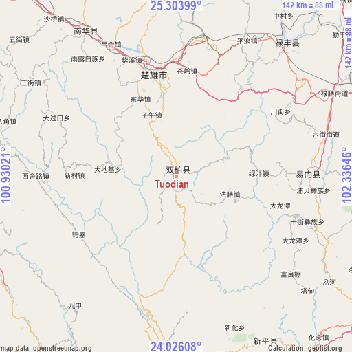
Tuodian GPS coordinates[2]
24° 40' 0.012" North, 101° 37' 59.988" East
| Map corner | latitude | longitude |
|---|---|---|
| Upper-left | 25.30399°, | 100.93021° |
| Center: | 24.66667°, | 101.63333° |
| Lower-right: | 24.02608°, | 102.33646° |
| Map W x H: | 142.1×142.1 km | = 88.3×88.3mi |
| max Lat: | 53.31946° ⇑87.8% North |
| Tuodian: | 24.66667° |
| min Lat: | ⇓12.2% South 18.22056° |
| min Long | Tuodian | max Long |
| 75.07348° | 101.63333° | 134.28917° |
| W 6.7%⇐ | ⇒93.3% E |
Elevation
Elevation of Tuodian is 1855 m = 6086 ft, and this is 1370.2 m = 4495 ft above average elevation for this country.
| Max E: |
5622 m = 18445 ft | 6.1% |
| Tuodian | 1855 m 6086 ft | |
| Avg. | 484.8 m = 1591 ft | |
Min E: |
-3 m = -10 ft | 93.9% |
See also: China elevation on elevation.city.
Geographical zone
Tuodian is located in North temperate zone (between Tropic of Cancer and the Arctic Circle). Distance of this Northern Tropic circle is 136.8 km =85 mi to South.| Distance of | km | miles | from Tuodian |
|---|---|---|---|
| North Pole | 7264.4 | 4513.9 | to North |
| Arctic Circle | 4658.5 | 2894.7 | to North |
| Tropic Cancer | 136.8 | 85 | to South |
| Equator | 2742.7 | 1704.2 | to South |


Nearby cities:
15 places around Tuodian: (largest is in red/bold)
• Dalongtan
54.5 km =33.9 mi,  118°
118°
• Dengzishan
48.9 km =30.4 mi,  58°
58°
• Dianzhong
66.5 km =41.3 mi, 115°
• Fuliangpengjie
60.5 km =37.6 mi,  130°
130°
• Gonghe
66.5 km =41.3 mi,  349°
349°
• Jinshan
68.5 km =42.6 mi,  43°
43°
• Liujie
62.5 km =38.8 mi,  74°
74°
• Longchuan
64.8 km =40.3 mi,  328°
328°
• Longquan
53.4 km =33.2 mi,  89°
89°
• Shijie
56.2 km =34.9 mi,  109°
109°
• Tongchang
40.9 km =25.4 mi,  82°
82°
• Tuguan
65.1 km =40.5 mi, 61°
• Xiaojie
55.2 km =34.3 mi, 66°
• Xinjiezi
55.7 km =34.6 mi,  95°
95°
• Xiyang
70.2 km =43.6 mi, 108°
Sources, notices
• [Note1] Compared only with cities in China existing in our database
• [Src1] Map data: © OpenStreetMap contributors (CC-BY-SA)
• [Src2] Other city data from geonames.org with taken over terms of usage.
• [Src3] Geographical zone / Annual Mean Temperature by Robert A. Rohde @ Wikipedia
