Binhe geodata
Binhe (Henan) is a seat of a third-order administrative division; located in China in Asia/Shanghai (GMT+8) time zone. With population of 68,514 people, there are 623 cities with bigger population in this country. Compared to other cities in China, 64.8% of cities are located further ↓South; 58.6% of cities are located further →East and 58.4% of cities have higher elevation than Binhe. Note1


Binhe GPS coordinates[2]
32° 41' 17.988" North, 112° 49' 39" East
| Map corner | latitude | longitude |
|---|---|---|
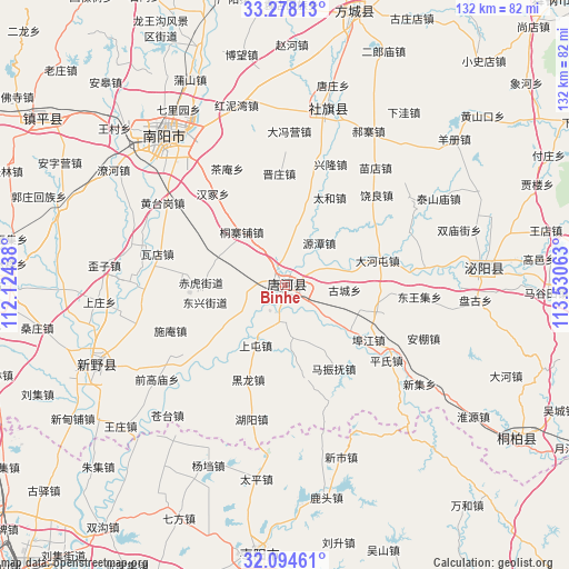
| Upper-left | 33.27813°, | 112.12438° |
| Center: | 32.68833°, | 112.8275° |
| Lower-right: | 32.09461°, | 113.53063° |
| Map W x H: | 131.6×131.6 km | = 81.8×81.8mi |
| max Lat: | 53.31946° ⇑35.2% North |
| Binhe: | 32.68833° |
| min Lat: | ⇓64.8% South 18.22056° |
| min Long | Binhe | max Long |
| 75.07348° | 112.8275° | 134.28917° |
| W 41.4%⇐ | ⇒58.6% E |
Elevation
Elevation of Binhe is 109 m = 358 ft, and this is 375.8 m = 1233 ft below average elevation for this country.
| Max E: |
5622 m = 18445 ft | 58.4% |
| Avg. | 484.8 m = 1591 ft | |
| Binhe | 109 m = 358 ft | |
Min E: |
-3 m = -10 ft | 41.6% |
See also: Binhe elevation on elevation.city.
Geographical zone
Binhe is located in North temperate zone (between Tropic of Cancer and the Arctic Circle). Distance of this Northern Tropic circle is 1028.7 km =639.2 mi to South.| Distance of | km | miles | from Binhe |
|---|---|---|---|
| North Pole | 6372.5 | 3959.7 | to North |
| Arctic Circle | 3766.6 | 2340.5 | to North |
| Tropic Cancer | 1028.7 | 639.2 | to South |
| Equator | 3634.6 | 2258.4 | to South |


Nearby cities:
15 places around Binhe: (largest is in red/bold)
• Chengjiao
41.2 km =25.6 mi,  12°
12°
• Chenzhuang
44.1 km =27.4 mi,  94°
94°
• Dafengying
35.4 km =22 mi,  2°
2°
• Gaodian
38.6 km =24 mi,  98°
98°
• Guoji
42.4 km =26.3 mi,  40°
40°
• Haozhai
40.6 km =25.2 mi,  28°
28°
• Huancheng
45.2 km =28.1 mi,  323°
323°
• Nanyang
43.8 km =27.2 mi, 321°
• Qiaotou
40.8 km =25.4 mi,  357°
357°
• Shedian
42.8 km =26.6 mi, 14°
• Shewan
39 km =24.2 mi,  82°
82°
• Shuangmiaojie
42.3 km =26.3 mi,  72°
72°
• Taiping
45.2 km =28.1 mi,  188°
188°
• Taishanmiao
40.9 km =25.4 mi,  60°
60°
• Xinshi
41.4 km =25.7 mi,  161°
161°
Sources, notices
• [Note1] Compared only with cities in China existing in our database
• [Src1] Map data: © OpenStreetMap contributors (CC-BY-SA)
• [Src2] Other city data from geonames.org with taken over terms of usage.
• [Src3] Geographical zone / Annual Mean Temperature by Robert A. Rohde @ Wikipedia
