Dafengying geodata
Dafengying (Henan) is a seat of a fourth-order administrative division; located in China in Asia/Shanghai (GMT+8) time zone. In our database, there are 1268 cities with bigger population. Compared to other cities in China, 66.1% of cities are located further ↓South; 58.5% of cities are located further →East and 56% of cities have higher elevation than Dafengying. Note1


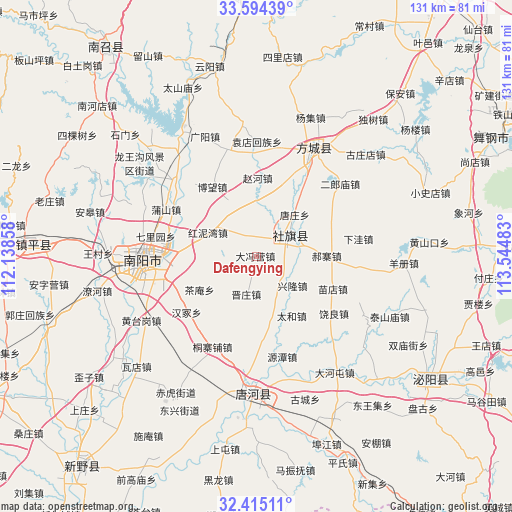
Dafengying GPS coordinates[2]
33° 0' 24.192" North, 112° 50' 30.12" East
| Map corner | latitude | longitude |
|---|---|---|
| Upper-left | 33.59439°, | 112.13858° |
| Center: | 33.00672°, | 112.8417° |
| Lower-right: | 32.41511°, | 113.54483° |
| Map W x H: | 131.1×131.1 km | = 81.5×81.5mi |
| max Lat: | 53.31946° ⇑33.9% North |
| Dafengying: | 33.00672° |
| min Lat: | ⇓66.1% South 18.22056° |
| min Long | Dafengying | max Long |
| 75.07348° | 112.8417° | 134.28917° |
| W 41.5%⇐ | ⇒58.5% E |
Elevation
Elevation of Dafengying is 124 m = 407 ft, and this is 360.8 m = 1184 ft below average elevation for this country.
| Max E: |
5622 m = 18445 ft | 56% |
| Avg. | 484.8 m = 1591 ft | |
| Dafengying | 124 m = 407 ft | |
Min E: |
-3 m = -10 ft | 44% |
See also: China elevation on elevation.city.
Geographical zone
Dafengying is located in North temperate zone (between Tropic of Cancer and the Arctic Circle). Distance of this Northern Tropic circle is 1064.1 km =661.2 mi to South.| Distance of | km | miles | from Dafengying |
|---|---|---|---|
| North Pole | 6337.1 | 3937.7 | to North |
| Arctic Circle | 3731.2 | 2318.5 | to North |
| Tropic Cancer | 1064.1 | 661.2 | to South |
| Equator | 3670 | 2280.4 | to South |


Nearby cities:
15 places around Dafengying: (largest is in red/bold)
• Bowang
20.6 km =12.8 mi,  334°
334°
• Chengjiao
9.2 km =5.7 mi,  58°
58°
• Fangcheng Chengguanzhen
31.2 km =19.4 mi,  28°
28°
• Guoji
26.3 km =16.3 mi,  96°
96°
• Haozhai
18 km =11.2 mi,  88°
88°
• Huancheng
28.2 km =17.5 mi,  271°
271°
• Nanyang
28.8 km =17.9 mi, 267°
• Pushan
26.2 km =16.3 mi,  298°
298°
• Qiaotou
6.1 km =3.8 mi, 331°
• Qinghe
27.8 km =17.3 mi,  12°
12°
• Shedian
11.2 km =7 mi, 57°
• Tangzhuang
14.6 km =9.1 mi,  42°
42°
• Xuanqiao
19.7 km =12.2 mi, 34°
• Yuandianhui
29.5 km =18.3 mi,  0°
0°
• Zhaohe
20.1 km =12.5 mi, 0°
Sources, notices
• [Note1] Compared only with cities in China existing in our database
• [Src1] Map data: © OpenStreetMap contributors (CC-BY-SA)
• [Src2] Other city data from geonames.org with taken over terms of usage.
• [Src3] Geographical zone / Annual Mean Temperature by Robert A. Rohde @ Wikipedia
