Taiping geodata
Taiping (Guangdong) is a seat of a fourth-order administrative division; located in China in Asia/Shanghai (GMT+8) time zone. In our database, there are 1268 cities with bigger population. Compared to other cities in China, 92.4% of cities are located further ↑North; 54.5% of cities are located further →East and 80.2% of cities have higher elevation than Taiping. Note1


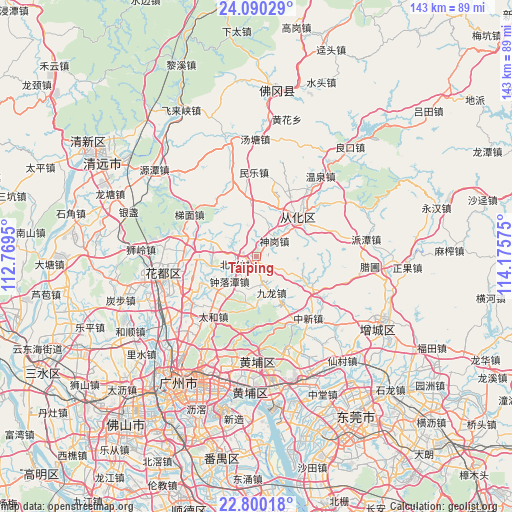
Taiping GPS coordinates[2]
23° 26' 48.516" North, 113° 28' 21.432" East
| Map corner | latitude | longitude |
|---|---|---|
| Upper-left | 24.09029°, | 112.7695° |
| Center: | 23.44681°, | 113.47262° |
| Lower-right: | 22.80018°, | 114.17575° |
| Map W x H: | 143.4×143.4 km | = 89.1×89.1mi |
| max Lat: | 53.31946° ⇑92.4% North |
| Taiping: | 23.44681° |
| min Lat: | ⇓7.6% South 18.22056° |
| min Long | Taiping | max Long |
| 75.07348° | 113.47262° | 134.28917° |
| W 45.5%⇐ | ⇒54.5% E |
Elevation
Elevation of Taiping is 26 m = 85 ft, and this is 458.8 m = 1505 ft below average elevation for this country.
| Max E: |
5622 m = 18445 ft | 80.2% |
| Avg. | 484.8 m = 1591 ft | |
| Taiping | 26 m = 85 ft | |
Min E: |
-3 m = -10 ft | 19.8% |
See also: China elevation on elevation.city.
Geographical zone
Taiping is located in North temperate zone (between Tropic of Cancer and the Arctic Circle). Distance of this Northern Tropic circle is 1.1 km =0.7 mi to South.| Distance of | km | miles | from Taiping |
|---|---|---|---|
| North Pole | 7400 | 4598.1 | to North |
| Arctic Circle | 4794.1 | 2978.9 | to North |
| Tropic Cancer | 1.1 | 0.7 | to South |
| Equator | 2607 | 1619.9 | to South |


Nearby cities:
15 places around Taiping: (largest is in red/bold)
• Aotou
20.2 km =12.6 mi,  343°
343°
• Chengjiao
16.7 km =10.4 mi,  37°
37°
• Huadong
15.3 km =9.5 mi,  265°
265°
• Huashan
20.9 km =13 mi, 270°
• Jiangpu
16.7 km =10.4 mi,  49°
49°
• Jiekou
15.9 km =9.9 mi, 43°
• Jiulong
10.2 km =6.3 mi,  157°
157°
• Lianhe
26.5 km =16.5 mi,  194°
194°
• Minle
23.6 km =14.7 mi,  358°
358°
• Renhe
22.4 km =13.9 mi,  235°
235°
• Shengang
6.7 km =4.2 mi, 49°
• Taihe
21.3 km =13.2 mi,  216°
216°
• Timian
22 km =13.7 mi,  301°
301°
• Zhongluotan
10.6 km =6.6 mi,  229°
229°
• Zhongxin
22.7 km =14.1 mi,  141°
141°
Sources, notices
• [Note1] Compared only with cities in China existing in our database
• [Src1] Map data: © OpenStreetMap contributors (CC-BY-SA)
• [Src2] Other city data from geonames.org with taken over terms of usage.
• [Src3] Geographical zone / Annual Mean Temperature by Robert A. Rohde @ Wikipedia
