Aotou geodata
Aotou (Guangdong) is a seat of a fourth-order administrative division; located in China in Asia/Shanghai (GMT+8) time zone. In our database, there are 1268 cities with bigger population. Compared to other cities in China, 91.7% of cities are located further ↑North; 54.9% of cities are located further →East and 78.3% of cities have higher elevation than Aotou. Note1


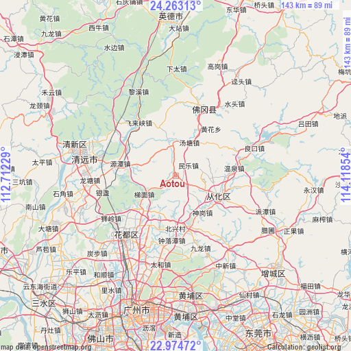
Aotou GPS coordinates[2]
23° 37' 13.836" North, 113° 24' 55.476" East
| Map corner | latitude | longitude |
|---|---|---|
| Upper-left | 24.26313°, | 112.71229° |
| Center: | 23.62051°, | 113.41541° |
| Lower-right: | 22.97472°, | 114.11854° |
| Map W x H: | 143.3×143.3 km | = 89×89mi |
| max Lat: | 53.31946° ⇑91.7% North |
| Aotou: | 23.62051° |
| min Lat: | ⇓8.3% South 18.22056° |
| min Long | Aotou | max Long |
| 75.07348° | 113.41541° | 134.28917° |
| W 45.1%⇐ | ⇒54.9% E |
Elevation
Elevation of Aotou is 30 m = 98 ft, and this is 454.8 m = 1492 ft below average elevation for this country.
| Max E: |
5622 m = 18445 ft | 78.3% |
| Avg. | 484.8 m = 1591 ft | |
| Aotou | 30 m = 98 ft | |
Min E: |
-3 m = -10 ft | 21.7% |
See also: China elevation on elevation.city.
Geographical zone
Aotou is located in North temperate zone (between Tropic of Cancer and the Arctic Circle). Distance of this Northern Tropic circle is 20.4 km =12.7 mi to South.| Distance of | km | miles | from Aotou |
|---|---|---|---|
| North Pole | 7380.7 | 4586.2 | to North |
| Arctic Circle | 4774.8 | 2966.9 | to North |
| Tropic Cancer | 20.4 | 12.7 | to South |
| Equator | 2626.4 | 1632 | to South |


Nearby cities:
15 places around Aotou: (largest is in red/bold)
• Chengjiao
17.2 km =10.7 mi,  110°
110°
• Feilaixia
24 km =14.9 mi,  310°
310°
• Huadong
22.5 km =14 mi,  204°
204°
• Huashan
24.2 km =15 mi,  218°
218°
• Jiangkou
23.6 km =14.7 mi,  303°
303°
• Jiangpu
20.3 km =12.6 mi, 114°
• Jiekou
18.6 km =11.6 mi, 114°
• Longshan
14.7 km =9.1 mi,  349°
349°
• Minle
6.8 km =4.2 mi,  50°
50°
• Shengang
18.6 km =11.6 mi,  143°
143°
• Taiping
20.2 km =12.6 mi,  163°
163°
• Tangtang
14.6 km =9.1 mi,  21°
21°
• Timian
15.2 km =9.4 mi,  238°
238°
• Wenquan
24.1 km =15 mi,  82°
82°
• Yuantan
22.7 km =14.1 mi,  283°
283°
Sources, notices
• [Note1] Compared only with cities in China existing in our database
• [Src1] Map data: © OpenStreetMap contributors (CC-BY-SA)
• [Src2] Other city data from geonames.org with taken over terms of usage.
• [Src3] Geographical zone / Annual Mean Temperature by Robert A. Rohde @ Wikipedia
