Taiping geodata
Taiping (Guangdong) is a seat of a fourth-order administrative division; located in China in Asia/Shanghai (GMT+8) time zone. In our database, there are 1268 cities with bigger population. Compared to other cities in China, 91.4% of cities are located further ↑North; 58.2% of cities are located further →East and 85.5% of cities have higher elevation than Taiping. Note1


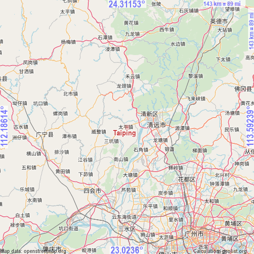
Taiping GPS coordinates[2]
23° 40' 8.94" North, 112° 53' 21.336" East
| Map corner | latitude | longitude |
|---|---|---|
| Upper-left | 24.31153°, | 112.18614° |
| Center: | 23.66915°, | 112.88926° |
| Lower-right: | 23.0236°, | 113.59239° |
| Map W x H: | 143.2×143.2 km | = 89×89mi |
| max Lat: | 53.31946° ⇑91.4% North |
| Taiping: | 23.66915° |
| min Lat: | ⇓8.6% South 18.22056° |
| min Long | Taiping | max Long |
| 75.07348° | 112.88926° | 134.28917° |
| W 41.8%⇐ | ⇒58.2% E |
Elevation
Elevation of Taiping is 15 m = 49 ft, and this is 469.8 m = 1541 ft below average elevation for this country.
| Max E: |
5622 m = 18445 ft | 85.5% |
| Avg. | 484.8 m = 1591 ft | |
| Taiping | 15 m = 49 ft | |
Min E: |
-3 m = -10 ft | 14.5% |
See also: China elevation on elevation.city.
Geographical zone
Taiping is located in North temperate zone (between Tropic of Cancer and the Arctic Circle). Distance of this Northern Tropic circle is 25.8 km =16 mi to South.| Distance of | km | miles | from Taiping |
|---|---|---|---|
| North Pole | 7375.3 | 4582.8 | to North |
| Arctic Circle | 4769.4 | 2963.6 | to North |
| Tropic Cancer | 25.8 | 16 | to South |
| Equator | 2631.8 | 1635.3 | to South |


Nearby cities:
15 places around Taiping: (largest is in red/bold)
• Didou
22 km =13.7 mi,  238°
238°
• Dongcheng
18.6 km =11.6 mi,  67°
67°
• Fengcheng
16.1 km =10 mi,  62°
62°
• Henghe
17.8 km =11.1 mi,  103°
103°
• Jingkou
19.1 km =11.9 mi,  200°
200°
• Longjing
22.9 km =14.2 mi,  346°
346°
• Longtang
20 km =12.4 mi,  112°
112°
• Luoyuan
17.3 km =10.7 mi,  234°
234°
• Qingyuan
15.1 km =9.4 mi,  76°
76°
• Sankeng
11.9 km =7.4 mi, 229°
• Shantang
7.7 km =4.8 mi,  117°
117°
• Shijiao
15.4 km =9.6 mi,  147°
147°
• Taihe
11.6 km =7.2 mi,  50°
50°
• Weizheng
16.2 km =10.1 mi,  262°
262°
• Zhouxin
20 km =12.4 mi,  85°
85°
Sources, notices
• [Note1] Compared only with cities in China existing in our database
• [Src1] Map data: © OpenStreetMap contributors (CC-BY-SA)
• [Src2] Other city data from geonames.org with taken over terms of usage.
• [Src3] Geographical zone / Annual Mean Temperature by Robert A. Rohde @ Wikipedia
