Shijiao geodata
Shijiao (Guangdong) is a seat of a fourth-order administrative division; located in China in Asia/Shanghai (GMT+8) time zone. In our database, there are 1268 cities with bigger population. Compared to other cities in China, 91.9% of cities are located further ↑North; 57.8% of cities are located further →East and 95.9% of cities have higher elevation than Shijiao. Note1


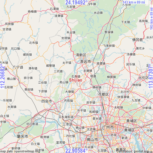
Shijiao GPS coordinates[2]
23° 33' 7.056" North, 112° 58' 11.784" East
| Map corner | latitude | longitude |
|---|---|---|
| Upper-left | 24.19492°, | 112.26682° |
| Center: | 23.55196°, | 112.96994° |
| Lower-right: | 22.90584°, | 113.67307° |
| Map W x H: | 143.3×143.3 km | = 89×89mi |
| max Lat: | 53.31946° ⇑91.9% North |
| Shijiao: | 23.55196° |
| min Lat: | ⇓8.1% South 18.22056° |
| min Long | Shijiao | max Long |
| 75.07348° | 112.96994° | 134.28917° |
| W 42.2%⇐ | ⇒57.8% E |
Elevation
Elevation of Shijiao is 6 m = 20 ft, and this is 478.8 m = 1571 ft below average elevation for this country.
| Max E: |
5622 m = 18445 ft | 95.9% |
| Avg. | 484.8 m = 1591 ft | |
| Shijiao | 6 m = 20 ft | |
Min E: |
-3 m = -10 ft | 4.1% |
See also: China elevation on elevation.city.
Geographical zone
Shijiao is located in North temperate zone (between Tropic of Cancer and the Arctic Circle). Distance of this Northern Tropic circle is 12.8 km =8 mi to South.| Distance of | km | miles | from Shijiao |
|---|---|---|---|
| North Pole | 7388.3 | 4590.9 | to North |
| Arctic Circle | 4782.4 | 2971.6 | to North |
| Tropic Cancer | 12.8 | 8 | to South |
| Equator | 2618.7 | 1627.2 | to South |


Nearby cities:
15 places around Shijiao: (largest is in red/bold)
• Chini
17.1 km =10.6 mi,  170°
170°
• Datang
14.4 km =8.9 mi,  212°
212°
• Dongcheng
22 km =13.7 mi,  24°
24°
• Fengcheng
21.3 km =13.2 mi, 16°
• Henghe
12.8 km =8 mi,  45°
45°
• Jingkou
15.6 km =9.7 mi,  251°
251°
• Longtang
11.5 km =7.1 mi,  62°
62°
• Luoyuan
22.5 km =14 mi,  277°
277°
• Qingyuan
17.7 km =11 mi, 21°
• Sankeng
18.1 km =11.2 mi,  287°
287°
• Shantang
9.6 km =6 mi,  351°
351°
• Shiling
21.4 km =13.3 mi,  119°
119°
• Taihe
20.4 km =12.7 mi,  2°
2°
• Taiping
15.4 km =9.6 mi,  327°
327°
• Zhouxin
18.8 km =11.7 mi,  38°
38°
Sources, notices
• [Note1] Compared only with cities in China existing in our database
• [Src1] Map data: © OpenStreetMap contributors (CC-BY-SA)
• [Src2] Other city data from geonames.org with taken over terms of usage.
• [Src3] Geographical zone / Annual Mean Temperature by Robert A. Rohde @ Wikipedia
