Sankeng geodata
Sankeng (Guangdong) is a seat of a fourth-order administrative division; located in China in Asia/Shanghai (GMT+8) time zone. In our database, there are 1268 cities with bigger population. Compared to other cities in China, 91.7% of cities are located further ↑North; 58.7% of cities are located further →East and 82.9% of cities have higher elevation than Sankeng. Note1


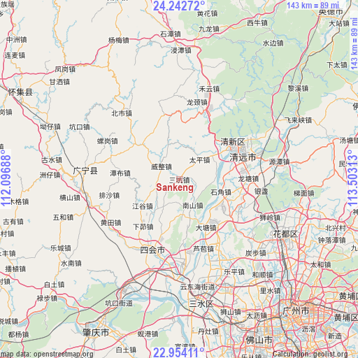
Sankeng GPS coordinates[2]
23° 36' 0" North, 112° 48' 0" East
| Map corner | latitude | longitude |
|---|---|---|
| Upper-left | 24.24272°, | 112.09688° |
| Center: | 23.6°, | 112.8° |
| Lower-right: | 22.95411°, | 113.50313° |
| Map W x H: | 143.3×143.3 km | = 89×89mi |
| max Lat: | 53.31946° ⇑91.7% North |
| Sankeng: | 23.6° |
| min Lat: | ⇓8.3% South 18.22056° |
| min Long | Sankeng | max Long |
| 75.07348° | 112.8° | 134.28917° |
| W 41.3%⇐ | ⇒58.7% E |
Elevation
Elevation of Sankeng is 20 m = 66 ft, and this is 464.8 m = 1525 ft below average elevation for this country.
| Max E: |
5622 m = 18445 ft | 82.9% |
| Avg. | 484.8 m = 1591 ft | |
| Sankeng | 20 m = 66 ft | |
Min E: |
-3 m = -10 ft | 17.1% |
See also: China elevation on elevation.city.
Geographical zone
Sankeng is located in North temperate zone (between Tropic of Cancer and the Arctic Circle). Distance of this Northern Tropic circle is 18.2 km =11.3 mi to South.| Distance of | km | miles | from Sankeng |
|---|---|---|---|
| North Pole | 7383 | 4587.6 | to North |
| Arctic Circle | 4777.1 | 2968.4 | to North |
| Tropic Cancer | 18.2 | 11.3 | to South |
| Equator | 2624.1 | 1630.5 | to South |


Nearby cities:
15 places around Sankeng: (largest is in red/bold)
• Datang
20 km =12.4 mi,  151°
151°
• Didou
10.4 km =6.5 mi,  247°
247°
• Jianggu
17.8 km =11.1 mi,  234°
234°
• Jiangtun
22.8 km =14.2 mi,  305°
305°
• Jingkou
10.6 km =6.6 mi,  166°
166°
• Lianhe
20.8 km =12.9 mi, 314°
• Luoyuan
5.5 km =3.4 mi,  244°
244°
• Qingyuan
26.2 km =16.3 mi,  64°
64°
• Shantang
16.4 km =10.2 mi,  75°
75°
• Shijiao
18.1 km =11.2 mi,  107°
107°
• Taihe
23.5 km =14.6 mi,  50°
50°
• Taiping
11.9 km =7.4 mi, 49°
• Tanbu
24.6 km =15.3 mi,  275°
275°
• Weizheng
9 km =5.6 mi, 308°
• Xiamao
24.7 km =15.3 mi,  215°
215°
Sources, notices
• [Note1] Compared only with cities in China existing in our database
• [Src1] Map data: © OpenStreetMap contributors (CC-BY-SA)
• [Src2] Other city data from geonames.org with taken over terms of usage.
• [Src3] Geographical zone / Annual Mean Temperature by Robert A. Rohde @ Wikipedia
