Sijia geodata
Sijia (Jiangsu) is a seat of a fourth-order administrative division; located in China in Asia/Shanghai (GMT+8) time zone. In our database, there are 1268 cities with bigger population. Compared to other cities in China, 61.2% of cities are located further ↓South; 89% of cities are located further ←West and 98.3% of cities have higher elevation than Sijia. Note1


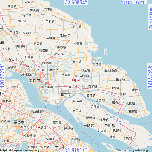
Sijia GPS coordinates[2]
32° 0' 51.444" North, 121° 16' 32.988" East
| Map corner | latitude | longitude |
|---|---|---|
| Upper-left | 32.60854°, | 120.57271° |
| Center: | 32.01429°, | 121.27583° |
| Lower-right: | 31.41617°, | 121.97896° |
| Map W x H: | 132.6×132.6 km | = 82.4×82.4mi |
| max Lat: | 53.31946° ⇑38.8% North |
| Sijia: | 32.01429° |
| min Lat: | ⇓61.2% South 18.22056° |
| min Long | Sijia | max Long |
| 75.07348° | 121.27583° | 134.28917° |
| W 89%⇐ | ⇒11% E |
Elevation
Elevation of Sijia is 4 m = 13 ft, and this is 480.8 m = 1577 ft below average elevation for this country.
| Max E: |
5622 m = 18445 ft | 98.3% |
| Avg. | 484.8 m = 1591 ft | |
| Sijia | 4 m = 13 ft | |
Min E: |
-3 m = -10 ft | 1.7% |
See also: China elevation on elevation.city.
Geographical zone
Sijia is located in North temperate zone (between Tropic of Cancer and the Arctic Circle). Distance of this Northern Tropic circle is 953.7 km =592.6 mi to South.| Distance of | km | miles | from Sijia |
|---|---|---|---|
| North Pole | 6447.4 | 4006.2 | to North |
| Arctic Circle | 3841.5 | 2387 | to North |
| Tropic Cancer | 953.7 | 592.6 | to South |
| Equator | 3559.7 | 2211.9 | to South |


Nearby cities:
15 places around Sijia: (largest is in red/bold)
• Antou
6.5 km =4 mi,  36°
36°
• Baochang
14.1 km =8.8 mi,  69°
69°
• Batou
12.2 km =7.6 mi,  238°
238°
• Changle
9.3 km =5.8 mi,  196°
196°
• Dongshe
12.8 km =8 mi,  315°
315°
• Erjia
8.6 km =5.3 mi,  276°
276°
• Huolong
4.7 km =2.9 mi,  354°
354°
• Qilin
11.1 km =6.9 mi,  141°
141°
• Sanchang
13.7 km =8.5 mi,  193°
193°
• Sanxing
16 km =9.9 mi,  251°
251°
• Sanyu
12.9 km =8 mi,  4°
4°
• Xiasanhe
14 km =8.7 mi,  104°
104°
• Xinhe
7.5 km =4.7 mi,  117°
117°
• Yudong
7.6 km =4.7 mi,  79°
79°
• Zhengyu
9.9 km =6.2 mi,  55°
55°
Sources, notices
• [Note1] Compared only with cities in China existing in our database
• [Src1] Map data: © OpenStreetMap contributors (CC-BY-SA)
• [Src2] Other city data from geonames.org with taken over terms of usage.
• [Src3] Geographical zone / Annual Mean Temperature by Robert A. Rohde @ Wikipedia
