Huolong geodata
Huolong (Jiangsu) is a seat of a fourth-order administrative division; located in China in Asia/Shanghai (GMT+8) time zone. In our database, there are 1268 cities with bigger population. Compared to other cities in China, 61.5% of cities are located further ↓South; 89% of cities are located further ←West and 92.7% of cities have higher elevation than Huolong. Note1


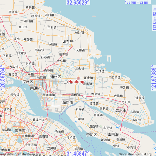
Huolong GPS coordinates[2]
32° 3' 22.752" North, 121° 16' 14.736" East
| Map corner | latitude | longitude |
|---|---|---|
| Upper-left | 32.65029°, | 120.56764° |
| Center: | 32.05632°, | 121.27076° |
| Lower-right: | 31.45847°, | 121.97389° |
| Map W x H: | 132.5×132.5 km | = 82.3×82.3mi |
| max Lat: | 53.31946° ⇑38.5% North |
| Huolong: | 32.05632° |
| min Lat: | ⇓61.5% South 18.22056° |
| min Long | Huolong | max Long |
| 75.07348° | 121.27076° | 134.28917° |
| W 89%⇐ | ⇒11% E |
Elevation
Elevation of Huolong is 8 m = 26 ft, and this is 476.8 m = 1564 ft below average elevation for this country.
| Max E: |
5622 m = 18445 ft | 92.7% |
| Avg. | 484.8 m = 1591 ft | |
| Huolong | 8 m = 26 ft | |
Min E: |
-3 m = -10 ft | 7.3% |
See also: China elevation on elevation.city.
Geographical zone
Huolong is located in North temperate zone (between Tropic of Cancer and the Arctic Circle). Distance of this Northern Tropic circle is 958.4 km =595.5 mi to South.| Distance of | km | miles | from Huolong |
|---|---|---|---|
| North Pole | 6442.7 | 4003.3 | to North |
| Arctic Circle | 3836.8 | 2384.1 | to North |
| Tropic Cancer | 958.4 | 595.5 | to South |
| Equator | 3564.3 | 2214.8 | to South |


Nearby cities:
15 places around Huolong: (largest is in red/bold)
• Antou
4.4 km =2.7 mi,  82°
82°
• Baochang
13.7 km =8.5 mi,  89°
89°
• Batou
14.8 km =9.2 mi,  222°
222°
• Changle
13.7 km =8.5 mi,  189°
189°
• Dongshe
9.6 km =6 mi,  298°
298°
• Erjia
8.8 km =5.5 mi,  245°
245°
• Haifeng
16 km =9.9 mi,  41°
41°
• Qilin
15.2 km =9.4 mi,  150°
150°
• Sanyu
8.3 km =5.2 mi,  10°
10°
• Sijia
4.7 km =2.9 mi,  174°
174°
• Wujia
12 km =7.5 mi,  325°
325°
• Xiasanhe
16.2 km =10.1 mi,  120°
120°
• Xinhe
10.8 km =6.7 mi,  138°
138°
• Yudong
8.6 km =5.3 mi,  112°
112°
• Zhengyu
8.6 km =5.3 mi, 83°
Sources, notices
• [Note1] Compared only with cities in China existing in our database
• [Src1] Map data: © OpenStreetMap contributors (CC-BY-SA)
• [Src2] Other city data from geonames.org with taken over terms of usage.
• [Src3] Geographical zone / Annual Mean Temperature by Robert A. Rohde @ Wikipedia
