Si’an geodata
Si’an (Jiangsu) is a seat of a fourth-order administrative division; located in China in Asia/Shanghai (GMT+8) time zone. In our database, there are 1268 cities with bigger population. Compared to other cities in China, 62.1% of cities are located further ↓South; 87.5% of cities are located further ←West and 94.3% of cities have higher elevation than Si’an. Note1


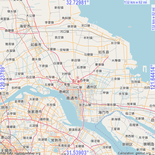
Si’an GPS coordinates[2]
32° 8' 10.896" North, 120° 56' 27.636" East
| Map corner | latitude | longitude |
|---|---|---|
| Upper-left | 32.72981°, | 120.23789° |
| Center: | 32.13636°, | 120.94101° |
| Lower-right: | 31.53903°, | 121.64414° |
| Map W x H: | 132.4×132.4 km | = 82.3×82.3mi |
| max Lat: | 53.31946° ⇑37.9% North |
| Si’an: | 32.13636° |
| min Lat: | ⇓62.1% South 18.22056° |
| min Long | Si’an | max Long |
| 75.07348° | 120.94101° | 134.28917° |
| W 87.5%⇐ | ⇒12.5% E |
Elevation
Elevation of Si’an is 7 m = 23 ft, and this is 477.8 m = 1568 ft below average elevation for this country.
| Max E: |
5622 m = 18445 ft | 94.3% |
| Avg. | 484.8 m = 1591 ft | |
| Si’an | 7 m = 23 ft | |
Min E: |
-3 m = -10 ft | 5.7% |
See also: China elevation on elevation.city.
Geographical zone
Si’an is located in North temperate zone (between Tropic of Cancer and the Arctic Circle). Distance of this Northern Tropic circle is 967.3 km =601.1 mi to South.| Distance of | km | miles | from Si’an |
|---|---|---|---|
| North Pole | 6433.8 | 3997.8 | to North |
| Arctic Circle | 3827.9 | 2378.5 | to North |
| Tropic Cancer | 967.3 | 601.1 | to South |
| Equator | 3573.2 | 2220.3 | to South |


Nearby cities:
15 places around Si’an: (largest is in red/bold)
• Chenqiao
13.6 km =8.5 mi,  254°
254°
• Guanyinshan
14.1 km =8.8 mi,  182°
182°
• Jinsha
13.5 km =8.4 mi,  112°
112°
• Liuqiao
10.4 km =6.5 mi,  290°
290°
• Nantong
13.3 km =8.3 mi,  207°
207°
• Qinzao
11 km =6.8 mi,  222°
222°
• Qi’an
11.2 km =7 mi,  65°
65°
• Shigang
9.7 km =6 mi,  19°
19°
• Tangzha
15.2 km =9.4 mi,  238°
238°
• Xianfeng
14.5 km =9 mi,  165°
165°
• Xindian
15.2 km =9.4 mi,  353°
353°
• Xingdong
6.5 km =4 mi,  156°
156°
• Xingfu
11.3 km =7 mi, 241°
• Xingren
7.9 km =4.9 mi, 180°
• Xiting
6.3 km =3.9 mi, 108°
Sources, notices
• [Note1] Compared only with cities in China existing in our database
• [Src1] Map data: © OpenStreetMap contributors (CC-BY-SA)
• [Src2] Other city data from geonames.org with taken over terms of usage.
• [Src3] Geographical zone / Annual Mean Temperature by Robert A. Rohde @ Wikipedia
