Shigang geodata
Shigang (Jiangsu) is a seat of a fourth-order administrative division; located in China in Asia/Shanghai (GMT+8) time zone. In our database, there are 1268 cities with bigger population. Compared to other cities in China, 62.5% of cities are located further ↓South; 87.7% of cities are located further ←West and 92.7% of cities have higher elevation than Shigang. Note1


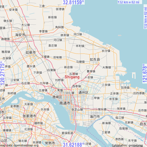
Shigang GPS coordinates[2]
32° 13' 7.248" North, 120° 58' 29.532" East
| Map corner | latitude | longitude |
|---|---|---|
| Upper-left | 32.81159°, | 120.27175° |
| Center: | 32.21868°, | 120.97487° |
| Lower-right: | 31.62188°, | 121.678° |
| Map W x H: | 132.3×132.3 km | = 82.2×82.2mi |
| max Lat: | 53.31946° ⇑37.5% North |
| Shigang: | 32.21868° |
| min Lat: | ⇓62.5% South 18.22056° |
| min Long | Shigang | max Long |
| 75.07348° | 120.97487° | 134.28917° |
| W 87.7%⇐ | ⇒12.3% E |
Elevation
Elevation of Shigang is 8 m = 26 ft, and this is 476.8 m = 1564 ft below average elevation for this country.
| Max E: |
5622 m = 18445 ft | 92.7% |
| Avg. | 484.8 m = 1591 ft | |
| Shigang | 8 m = 26 ft | |
Min E: |
-3 m = -10 ft | 7.3% |
See also: China elevation on elevation.city.
Geographical zone
Shigang is located in North temperate zone (between Tropic of Cancer and the Arctic Circle). Distance of this Northern Tropic circle is 976.5 km =606.8 mi to South.| Distance of | km | miles | from Shigang |
|---|---|---|---|
| North Pole | 6424.7 | 3992.1 | to North |
| Arctic Circle | 3818.8 | 2372.9 | to North |
| Tropic Cancer | 976.5 | 606.8 | to South |
| Equator | 3582.4 | 2226 | to South |


Nearby cities:
15 places around Shigang: (largest is in red/bold)
• Caobu
11.2 km =7 mi,  72°
72°
• Chahe
15.6 km =9.7 mi,  340°
340°
• Chenqiao
20.7 km =12.9 mi,  231°
231°
• Jinsha
17.1 km =10.6 mi,  147°
147°
• Liuqiao
14.1 km =8.8 mi,  246°
246°
• Matang
12.8 km =8 mi,  27°
27°
• Qinzao
20.2 km =12.6 mi,  211°
211°
• Qi’an
8.3 km =5.2 mi,  122°
122°
• Shizong
14.1 km =8.8 mi,  101°
101°
• Si’an
9.7 km =6 mi,  199°
199°
• Xindian
7.6 km =4.7 mi,  320°
320°
• Xingdong
15.1 km =9.4 mi,  182°
182°
• Xingfu
19.5 km =12.1 mi,  222°
222°
• Xingren
17.4 km =10.8 mi,  190°
190°
• Xiting
11.5 km =7.1 mi,  165°
165°
Sources, notices
• [Note1] Compared only with cities in China existing in our database
• [Src1] Map data: © OpenStreetMap contributors (CC-BY-SA)
• [Src2] Other city data from geonames.org with taken over terms of usage.
• [Src3] Geographical zone / Annual Mean Temperature by Robert A. Rohde @ Wikipedia
