Shucheng geodata
Shucheng (Jiangsu) is a seat of a third-order administrative division; located in China in Asia/Shanghai (GMT+8) time zone. In our database, there are 1268 cities with bigger population. Compared to other cities in China, 70.7% of cities are located further ↓South; 74.9% of cities are located further ←West and 92.7% of cities have higher elevation than Shucheng. Note1


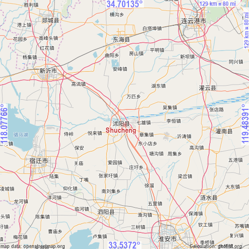
Shucheng GPS coordinates[2]
34° 7' 16.608" North, 118° 46' 50.808" East
| Map corner | latitude | longitude |
|---|---|---|
| Upper-left | 34.70135°, | 118.07766° |
| Center: | 34.12128°, | 118.78078° |
| Lower-right: | 33.5372°, | 119.48391° |
| Map W x H: | 129.4×129.4 km | = 80.4×80.4mi |
| max Lat: | 53.31946° ⇑29.3% North |
| Shucheng: | 34.12128° |
| min Lat: | ⇓70.7% South 18.22056° |
| min Long | Shucheng | max Long |
| 75.07348° | 118.78078° | 134.28917° |
| W 74.9%⇐ | ⇒25.1% E |
Elevation
Elevation of Shucheng is 8 m = 26 ft, and this is 476.8 m = 1564 ft below average elevation for this country.
| Max E: |
5622 m = 18445 ft | 92.7% |
| Avg. | 484.8 m = 1591 ft | |
| Shucheng | 8 m = 26 ft | |
Min E: |
-3 m = -10 ft | 7.3% |
See also: China elevation on elevation.city.
Geographical zone
Shucheng is located in North temperate zone (between Tropic of Cancer and the Arctic Circle). Distance of this Northern Tropic circle is 1188 km =738.2 mi to South.| Distance of | km | miles | from Shucheng |
|---|---|---|---|
| North Pole | 6213.1 | 3860.6 | to North |
| Arctic Circle | 3607.2 | 2241.4 | to North |
| Tropic Cancer | 1188 | 738.2 | to South |
| Equator | 3793.9 | 2357.4 | to South |


Nearby cities:
15 places around Shucheng: (largest is in red/bold)
• Dougou
35.8 km =22.2 mi,  59°
59°
• Gaogou
39.3 km =24.4 mi,  107°
107°
• Gaoxu
31.5 km =19.6 mi,  41°
41°
• Liheng
24.8 km =15.4 mi,  86°
86°
• Liji
43.5 km =27 mi, 92°
• Longju
40.1 km =24.9 mi,  47°
47°
• Machang
22.1 km =13.7 mi,  100°
100°
• Mengxingzhuang
40.6 km =25.2 mi,  81°
81°
• Muxu
42.8 km =26.6 mi, 45°
• Nangang
36.1 km =22.4 mi,  67°
67°
• Niushan
44.7 km =27.8 mi,  358°
358°
• Tangjian
20.6 km =12.8 mi, 86°
• Wuji
25.7 km =16 mi, 69°
• Yitao
29.7 km =18.5 mi, 98°
• Zhongxing
47.3 km =29.4 mi,  191°
191°
Sources, notices
• [Note1] Compared only with cities in China existing in our database
• [Src1] Map data: © OpenStreetMap contributors (CC-BY-SA)
• [Src2] Other city data from geonames.org with taken over terms of usage.
• [Src3] Geographical zone / Annual Mean Temperature by Robert A. Rohde @ Wikipedia
