Zhongxing geodata
Zhongxing (Jiangsu) is a populated place; located in China in Asia/Shanghai (GMT+8) time zone. With population of 57,338 people, there are 765 cities with bigger population in this country. Compared to other cities in China, 68.7% of cities are located further ↓South; 74.3% of cities are located further ←West and 84.3% of cities have higher elevation than Zhongxing. Note1


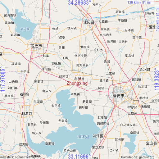
Zhongxing GPS coordinates[2]
33° 42' 14.004" North, 118° 40' 45.012" East
| Map corner | latitude | longitude |
|---|---|---|
| Upper-left | 34.28683°, | 117.97605° |
| Center: | 33.70389°, | 118.67917° |
| Lower-right: | 33.11696°, | 119.3823° |
| Map W x H: | 130.1×130.1 km | = 80.8×80.8mi |
| max Lat: | 53.31946° ⇑31.3% North |
| Zhongxing: | 33.70389° |
| min Lat: | ⇓68.7% South 18.22056° |
| min Long | Zhongxing | max Long |
| 75.07348° | 118.67917° | 134.28917° |
| W 74.3%⇐ | ⇒25.7% E |
Elevation
Elevation of Zhongxing is 17 m = 56 ft, and this is 467.8 m = 1535 ft below average elevation for this country.
| Max E: |
5622 m = 18445 ft | 84.3% |
| Avg. | 484.8 m = 1591 ft | |
| Zhongxing | 17 m = 56 ft | |
Min E: |
-3 m = -10 ft | 15.7% |
See also: Zhongxing elevation on elevation.city.
Geographical zone
Zhongxing is located in North temperate zone (between Tropic of Cancer and the Arctic Circle). Distance of this Northern Tropic circle is 1141.6 km =709.4 mi to South.| Distance of | km | miles | from Zhongxing |
|---|---|---|---|
| North Pole | 6259.5 | 3889.5 | to North |
| Arctic Circle | 3653.7 | 2270.3 | to North |
| Tropic Cancer | 1141.6 | 709.4 | to South |
| Equator | 3747.5 | 2328.6 | to South |


Nearby cities:
15 places around Zhongxing: (largest is in red/bold)
• Dougou
76 km =47.2 mi,  32°
32°
• Gaogou
58.6 km =36.4 mi,  53°
53°
• Guiren
45.5 km =28.3 mi,  265°
265°
• Huai'an
34 km =21.1 mi,  112°
112°
• Liheng
58.7 km =36.5 mi,  35°
35°
• Liji
69.2 km =43 mi, 49°
• Machang
52.4 km =32.6 mi, 36°
• Mengxingzhuang
72.1 km =44.8 mi, 43°
• Nangang
73.8 km =45.9 mi, 35°
• Qinggou
66.6 km =41.4 mi,  89°
89°
• Shucheng
47.3 km =29.4 mi,  11°
11°
• Suicheng
72.2 km =44.9 mi,  287°
287°
• Tangjian
56.4 km =35 mi, 32°
• Wuji
64.7 km =40.2 mi, 31°
• Yitao
57.3 km =35.6 mi, 42°
Sources, notices
• [Note1] Compared only with cities in China existing in our database
• [Src1] Map data: © OpenStreetMap contributors (CC-BY-SA)
• [Src2] Other city data from geonames.org with taken over terms of usage.
• [Src3] Geographical zone / Annual Mean Temperature by Robert A. Rohde @ Wikipedia
