Shatang geodata
Shatang (Guangdong) is a seat of a fourth-order administrative division; located in China in Asia/Shanghai (GMT+8) time zone. In our database, there are 1268 cities with bigger population. Compared to other cities in China, 96.5% of cities are located further ↑North; 59.6% of cities are located further →East and 94.3% of cities have higher elevation than Shatang. Note1


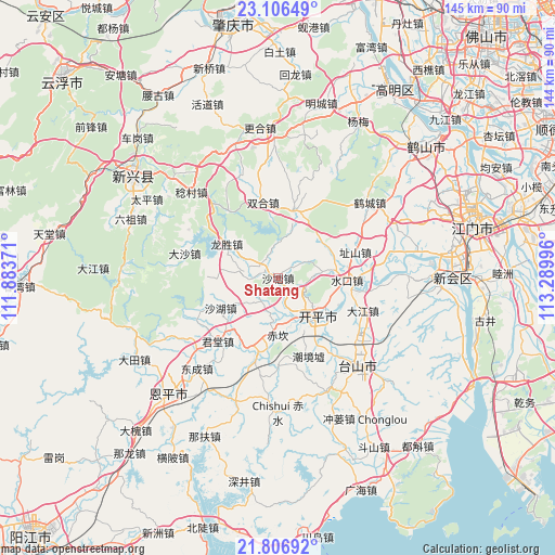
Shatang GPS coordinates[2]
22° 27' 29.628" North, 112° 35' 12.588" East
| Map corner | latitude | longitude |
|---|---|---|
| Upper-left | 23.10649°, | 111.88371° |
| Center: | 22.45823°, | 112.58683° |
| Lower-right: | 21.80692°, | 113.28996° |
| Map W x H: | 144.5×144.5 km | = 89.8×89.8mi |
| max Lat: | 53.31946° ⇑96.5% North |
| Shatang: | 22.45823° |
| min Lat: | ⇓3.5% South 18.22056° |
| min Long | Shatang | max Long |
| 75.07348° | 112.58683° | 134.28917° |
| W 40.4%⇐ | ⇒59.6% E |
Elevation
Elevation of Shatang is 7 m = 23 ft, and this is 477.8 m = 1568 ft below average elevation for this country.
| Max E: |
5622 m = 18445 ft | 94.3% |
| Avg. | 484.8 m = 1591 ft | |
| Shatang | 7 m = 23 ft | |
Min E: |
-3 m = -10 ft | 5.7% |
See also: China elevation on elevation.city.
Geographical zone
Shatang is located in North Torrid zone (between Equator and Tropic of Cancer). Distance of this Northern Tropic circle is 108.8 km =67.6 mi to North.| Distance of | km | miles | from Shatang |
|---|---|---|---|
| North Pole | 7509.9 | 4666.4 | to North |
| Arctic Circle | 4904.1 | 3047.3 | to North |
| Tropic Cancer | 108.8 | 67.6 | to North |
| Equator | 2497.1 | 1551.6 | to South |


Nearby cities:
15 places around Shatang: (largest is in red/bold)
• Cangcheng
4.5 km =2.8 mi,  298°
298°
• Changsha
13.2 km =8.2 mi,  130°
130°
• Chikan
15.1 km =9.4 mi,  182°
182°
• Longsheng
16.2 km =10.1 mi,  306°
306°
• Magang
9.9 km =6.2 mi,  282°
282°
• Sanba
19.9 km =12.4 mi,  150°
150°
• Sanbu
14.9 km =9.3 mi,  136°
136°
• Shahu
16.9 km =10.5 mi,  243°
243°
• Shuikou
18.2 km =11.3 mi,  91°
91°
• Tangkou
10.5 km =6.5 mi,  162°
162°
• Xiangang
20.1 km =12.5 mi,  195°
195°
• Yueshan
14.7 km =9.1 mi,  81°
81°
• Yunxiang
21.4 km =13.3 mi,  56°
56°
• Zhaiwu
18.3 km =11.4 mi,  13°
13°
• Zhishan
21.3 km =13.2 mi,  71°
71°
Sources, notices
• [Note1] Compared only with cities in China existing in our database
• [Src1] Map data: © OpenStreetMap contributors (CC-BY-SA)
• [Src2] Other city data from geonames.org with taken over terms of usage.
• [Src3] Geographical zone / Annual Mean Temperature by Robert A. Rohde @ Wikipedia
