Yunxiang geodata
Yunxiang (Guangdong) is a seat of a fourth-order administrative division; located in China in Asia/Shanghai (GMT+8) time zone. In our database, there are 1268 cities with bigger population. Compared to other cities in China, 96.2% of cities are located further ↑North; 58.9% of cities are located further →East and 78.3% of cities have higher elevation than Yunxiang. Note1


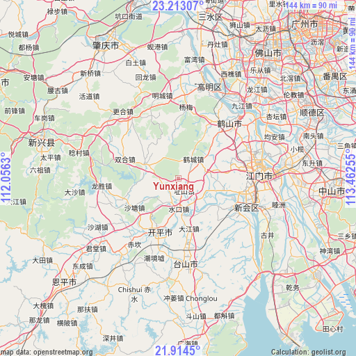
Yunxiang GPS coordinates[2]
22° 33' 55.116" North, 112° 45' 33.912" East
| Map corner | latitude | longitude |
|---|---|---|
| Upper-left | 23.21307°, | 112.0563° |
| Center: | 22.56531°, | 112.75942° |
| Lower-right: | 21.9145°, | 113.46255° |
| Map W x H: | 144.4×144.4 km | = 89.7×89.7mi |
| max Lat: | 53.31946° ⇑96.2% North |
| Yunxiang: | 22.56531° |
| min Lat: | ⇓3.8% South 18.22056° |
| min Long | Yunxiang | max Long |
| 75.07348° | 112.75942° | 134.28917° |
| W 41.1%⇐ | ⇒58.9% E |
Elevation
Elevation of Yunxiang is 30 m = 98 ft, and this is 454.8 m = 1492 ft below average elevation for this country.
| Max E: |
5622 m = 18445 ft | 78.3% |
| Avg. | 484.8 m = 1591 ft | |
| Yunxiang | 30 m = 98 ft | |
Min E: |
-3 m = -10 ft | 21.7% |
See also: China elevation on elevation.city.
Geographical zone
Yunxiang is located in North Torrid zone (between Equator and Tropic of Cancer). Distance of this Northern Tropic circle is 96.9 km =60.2 mi to North.| Distance of | km | miles | from Yunxiang |
|---|---|---|---|
| North Pole | 7498 | 4659 | to North |
| Arctic Circle | 4892.1 | 3039.8 | to North |
| Tropic Cancer | 96.9 | 60.2 | to North |
| Equator | 2509 | 1559 | to South |


Nearby cities:
15 places around Yunxiang: (largest is in red/bold)
• Cangcheng
23.8 km =14.8 mi,  245°
245°
• Changsha
21.9 km =13.6 mi,  200°
200°
• Dajiang
21.3 km =13.2 mi,  168°
168°
• Daze
18.6 km =11.6 mi,  105°
105°
• Gonghe
12.2 km =7.6 mi,  81°
81°
• Hecheng
10.1 km =6.3 mi,  34°
34°
• Luokeng
20 km =12.4 mi,  124°
124°
• Sanbu
23.8 km =14.8 mi, 198°
• Shatang
21.4 km =13.3 mi,  236°
236°
• Shuikou
12.3 km =7.6 mi,  177°
177°
• Siqian
12.4 km =7.7 mi,  128°
128°
• Taoyuan
23.4 km =14.5 mi,  41°
41°
• Yueshan
10.2 km =6.3 mi, 198°
• Zhaiwu
14.7 km =9.1 mi,  293°
293°
• Zhishan
5.9 km =3.7 mi,  154°
154°
Sources, notices
• [Note1] Compared only with cities in China existing in our database
• [Src1] Map data: © OpenStreetMap contributors (CC-BY-SA)
• [Src2] Other city data from geonames.org with taken over terms of usage.
• [Src3] Geographical zone / Annual Mean Temperature by Robert A. Rohde @ Wikipedia
