Shuangshu geodata
Shuangshu (Tianjin) is a populated place; located in China in Asia/Shanghai (GMT+8) time zone. With population of 2,134 people, there are 1020 cities with bigger population in this country. Compared to other cities in China, 84.8% of cities are located further ↓South; 66.1% of cities are located further ←West and 87.7% of cities have higher elevation than Shuangshu. Note1


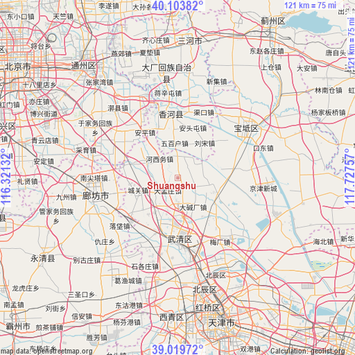
Shuangshu GPS coordinates[2]
39° 33' 50.004" North, 117° 1' 27.984" East
| Map corner | latitude | longitude |
|---|---|---|
| Upper-left | 40.10382°, | 116.32132° |
| Center: | 39.56389°, | 117.02444° |
| Lower-right: | 39.01972°, | 117.72757° |
| Map W x H: | 120.5×120.5 km | = 74.9×74.9mi |
| max Lat: | 53.31946° ⇑15.2% North |
| Shuangshu: | 39.56389° |
| min Lat: | ⇓84.8% South 18.22056° |
| min Long | Shuangshu | max Long |
| 75.07348° | 117.02444° | 134.28917° |
| W 66.1%⇐ | ⇒33.9% E |
Elevation
Elevation of Shuangshu is 12 m = 39 ft, and this is 472.8 m = 1551 ft below average elevation for this country.
| Max E: |
5622 m = 18445 ft | 87.7% |
| Avg. | 484.8 m = 1591 ft | |
| Shuangshu | 12 m = 39 ft | |
Min E: |
-3 m = -10 ft | 12.3% |
See also: China elevation on elevation.city.
Geographical zone
Shuangshu is located in North temperate zone (between Tropic of Cancer and the Arctic Circle). Distance of this Northern Tropic circle is 1793.2 km =1114.2 mi to South.| Distance of | km | miles | from Shuangshu |
|---|---|---|---|
| North Pole | 5608 | 3484.6 | to North |
| Arctic Circle | 3002.1 | 1865.4 | to North |
| Tropic Cancer | 1793.2 | 1114.2 | to South |
| Equator | 4399.1 | 2733.5 | to South |


Nearby cities:
15 places around Shuangshu: (largest is in red/bold)
• Beicaicun
8.5 km =5.3 mi,  179°
179°
• Chabaihu
15.2 km =9.4 mi,  135°
135°
• Changtun
14 km =8.7 mi,  163°
163°
• Cuihuangkou
14 km =8.7 mi,  107°
107°
• Dadunqiu
17.6 km =10.9 mi, 177°
• Dajianchang
10.8 km =6.7 mi,  152°
152°
• Dakoutun
17.7 km =11 mi,  82°
82°
• Daliang
6.6 km =4.1 mi, 114°
• Hebeitun
7.7 km =4.8 mi, 81°
• Houxiang
9.7 km =6 mi,  125°
125°
• Nancaicun
9.9 km =6.2 mi, 184°
• Nanrenfu
17 km =10.6 mi,  57°
57°
• Shimianzhuang
20.7 km =12.9 mi, 146°
• Xiawuqi
6.1 km =3.8 mi,  24°
24°
• Xinkaikou
19.1 km =11.9 mi,  48°
48°
Sources, notices
• [Note1] Compared only with cities in China existing in our database
• [Src1] Map data: © OpenStreetMap contributors (CC-BY-SA)
• [Src2] Other city data from geonames.org with taken over terms of usage.
• [Src3] Geographical zone / Annual Mean Temperature by Robert A. Rohde @ Wikipedia
