Dakoutun geodata
Dakoutun (Tianjin) is a populated place; located in China in Asia/Shanghai (GMT+8) time zone. With population of 5,814 people, there are 851 cities with bigger population in this country. Compared to other cities in China, 84.9% of cities are located further ↓South; 67.4% of cities are located further ←West and 89.9% of cities have higher elevation than Dakoutun. Note1


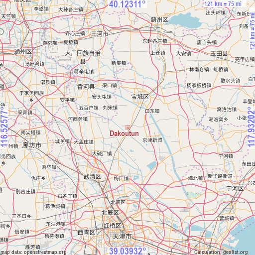
Dakoutun GPS coordinates[2]
39° 34' 59.988" North, 117° 13' 44.004" East
| Map corner | latitude | longitude |
|---|---|---|
| Upper-left | 40.12311°, | 116.52577° |
| Center: | 39.58333°, | 117.22889° |
| Lower-right: | 39.03932°, | 117.93202° |
| Map W x H: | 120.5×120.5 km | = 74.9×74.9mi |
| max Lat: | 53.31946° ⇑15.1% North |
| Dakoutun: | 39.58333° |
| min Lat: | ⇓84.9% South 18.22056° |
| min Long | Dakoutun | max Long |
| 75.07348° | 117.22889° | 134.28917° |
| W 67.4%⇐ | ⇒32.6% E |
Elevation
Elevation of Dakoutun is 10 m = 33 ft, and this is 474.8 m = 1558 ft below average elevation for this country.
| Max E: |
5622 m = 18445 ft | 89.9% |
| Avg. | 484.8 m = 1591 ft | |
| Dakoutun | 10 m = 33 ft | |
Min E: |
-3 m = -10 ft | 10.1% |
See also: China elevation on elevation.city.
Geographical zone
Dakoutun is located in North temperate zone (between Tropic of Cancer and the Arctic Circle). Distance of this Northern Tropic circle is 1795.3 km =1115.5 mi to South.| Distance of | km | miles | from Dakoutun |
|---|---|---|---|
| North Pole | 5605.8 | 3483.3 | to North |
| Arctic Circle | 2999.9 | 1864.1 | to North |
| Tropic Cancer | 1795.3 | 1115.5 | to South |
| Equator | 4401.3 | 2734.8 | to South |


Nearby cities:
15 places around Dakoutun: (largest is in red/bold)
• Badaogu
15 km =9.3 mi,  144°
144°
• Chabaihu
14.8 km =9.2 mi,  207°
207°
• Cuihuangkou
7.6 km =4.7 mi, 212°
• Daliang
12.5 km =7.8 mi,  246°
246°
• Hebeitun
9.9 km =6.2 mi,  264°
264°
• Houxiang
12.5 km =7.8 mi,  231°
231°
• Majiadian
8.9 km =5.5 mi,  21°
21°
• Nanrenfu
7.7 km =4.8 mi,  335°
335°
• Niujiapai
8.6 km =5.3 mi, 142°
• Shiqiao
13.3 km =8.3 mi,  25°
25°
• Sigaozhuang
13 km =8.1 mi,  171°
171°
• Xinkaikou
11.1 km =6.9 mi, 342°
• Yuguzhuang
12.8 km =8 mi,  60°
60°
• Zhongdeng
10.7 km =6.6 mi,  85°
85°
• Zhuangtou
9.9 km =6.2 mi, 33°
Sources, notices
• [Note1] Compared only with cities in China existing in our database
• [Src1] Map data: © OpenStreetMap contributors (CC-BY-SA)
• [Src2] Other city data from geonames.org with taken over terms of usage.
• [Src3] Geographical zone / Annual Mean Temperature by Robert A. Rohde @ Wikipedia
