Longbo geodata
Longbo (Hunan) is a seat of a third-order administrative division; located in China in Asia/Shanghai (GMT+8) time zone. In our database, there are 1268 cities with bigger population. Compared to other cities in China, 82.7% of cities are located further ↑North; 64.4% of cities are located further →East and 76.4% of cities have lower elevation than Longbo. Note1


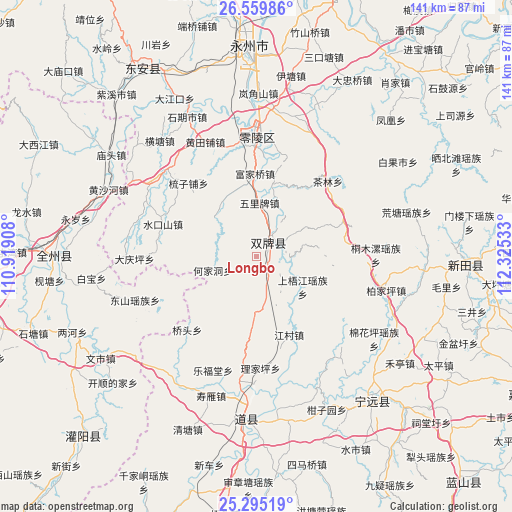
Longbo GPS coordinates[2]
25° 55' 45.192" North, 111° 37' 19.92" East
| Map corner | latitude | longitude |
|---|---|---|
| Upper-left | 26.55986°, | 110.91908° |
| Center: | 25.92922°, | 111.6222° |
| Lower-right: | 25.29519°, | 112.32533° |
| Map W x H: | 140.6×140.6 km | = 87.4×87.4mi |
| max Lat: | 53.31946° ⇑82.7% North |
| Longbo: | 25.92922° |
| min Lat: | ⇓17.3% South 18.22056° |
| min Long | Longbo | max Long |
| 75.07348° | 111.6222° | 134.28917° |
| W 35.6%⇐ | ⇒64.4% E |
Elevation
Elevation of Longbo is 557 m = 1827 ft, and this is 72.2 m = 237 ft above average elevation for this country.
| Max E: |
5622 m = 18445 ft | 23.6% |
| Longbo | 557 m 1827 ft | |
| Avg. | 484.8 m = 1591 ft | |
Min E: |
-3 m = -10 ft | 76.4% |
See also: China elevation on elevation.city.
Geographical zone
Longbo is located in North temperate zone (between Tropic of Cancer and the Arctic Circle). Distance of this Northern Tropic circle is 277.1 km =172.2 mi to South.| Distance of | km | miles | from Longbo |
|---|---|---|---|
| North Pole | 7124 | 4426.6 | to North |
| Arctic Circle | 4518.1 | 2807.4 | to North |
| Tropic Cancer | 277.1 | 172.2 | to South |
| Equator | 2883.1 | 1791.5 | to South |


Nearby cities:
15 places around Longbo: (largest is in red/bold)
• Baimadu
42.8 km =26.6 mi,  171°
171°
• Baimangpu
44.6 km =27.7 mi, 169°
• Daojiang
44.2 km =27.5 mi,  185°
185°
• Dongmen
45.1 km =28 mi,  181°
181°
• Futang
41.2 km =25.6 mi, 183°
• Hejiadong
13 km =8.1 mi,  248°
248°
• Huangtang
43 km =26.7 mi,  73°
73°
• Lefutang
33.4 km =20.8 mi,  200°
200°
• Majiang
22.2 km =13.8 mi,  78°
78°
• Shangrenli
4.5 km =2.8 mi,  152°
152°
• Shouyan
41.6 km =25.8 mi, 196°
• Shunling
48.6 km =30.2 mi,  140°
140°
• Tongmuluo
32.8 km =20.4 mi,  89°
89°
• Wanjiazhuang
48.1 km =29.9 mi, 186°
• Yongjiang
5.2 km =3.2 mi,  220°
220°
Sources, notices
• [Note1] Compared only with cities in China existing in our database
• [Src1] Map data: © OpenStreetMap contributors (CC-BY-SA)
• [Src2] Other city data from geonames.org with taken over terms of usage.
• [Src3] Geographical zone / Annual Mean Temperature by Robert A. Rohde @ Wikipedia
