Shunling geodata
Shunling (Hunan) is a seat of a third-order administrative division; located in China in Asia/Shanghai (GMT+8) time zone. In our database, there are 1268 cities with bigger population. Compared to other cities in China, 83.9% of cities are located further ↑North; 63% of cities are located further →East and 53.8% of cities have lower elevation than Shunling. Note1


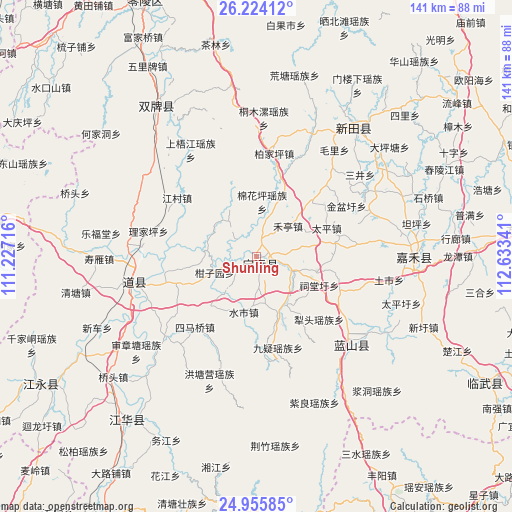
Shunling GPS coordinates[2]
25° 35' 30.012" North, 111° 55' 49.008" East
| Map corner | latitude | longitude |
|---|---|---|
| Upper-left | 26.22412°, | 111.22716° |
| Center: | 25.59167°, | 111.93028° |
| Lower-right: | 24.95585°, | 112.63341° |
| Map W x H: | 141×141 km | = 87.6×87.6mi |
| max Lat: | 53.31946° ⇑83.9% North |
| Shunling: | 25.59167° |
| min Lat: | ⇓16.1% South 18.22056° |
| min Long | Shunling | max Long |
| 75.07348° | 111.93028° | 134.28917° |
| W 37%⇐ | ⇒63% E |
Elevation
Elevation of Shunling is 196 m = 643 ft, and this is 288.8 m = 948 ft below average elevation for this country.
| Max E: |
5622 m = 18445 ft | 46.2% |
| Avg. | 484.8 m = 1591 ft | |
| Shunling | 196 m = 643 ft | |
Min E: |
-3 m = -10 ft | 53.8% |
See also: China elevation on elevation.city.
Geographical zone
Shunling is located in North temperate zone (between Tropic of Cancer and the Arctic Circle). Distance of this Northern Tropic circle is 239.6 km =148.9 mi to South.| Distance of | km | miles | from Shunling |
|---|---|---|---|
| North Pole | 7161.5 | 4449.9 | to North |
| Arctic Circle | 4555.6 | 2830.7 | to North |
| Tropic Cancer | 239.6 | 148.9 | to South |
| Equator | 2845.5 | 1768.1 | to South |


Nearby cities:
15 places around Shunling: (largest is in red/bold)
• Baimadu
24.7 km =15.3 mi,  258°
258°
• Baimangpu
23.8 km =14.8 mi,  254°
254°
• Bao’an
21.4 km =13.3 mi,  45°
45°
• Dongmen
33.1 km =20.6 mi, 256°
• Futang
33.4 km =20.8 mi, 263°
• Hengling
34.6 km =21.5 mi,  215°
215°
• Heting
11.7 km =7.3 mi, 47°
• Huiyuan
28.9 km =18 mi,  145°
145°
• Jiuyi
25.9 km =16.1 mi,  166°
166°
• Lengshui
11 km =6.8 mi,  112°
112°
• Litou
24.5 km =15.2 mi,  135°
135°
• Shizi
26.9 km =16.7 mi,  44°
44°
• Simaqiao
25.9 km =16.1 mi, 221°
• Taiping
20.8 km =12.9 mi,  68°
68°
• Tiantang
6.3 km =3.9 mi, 224°
Sources, notices
• [Note1] Compared only with cities in China existing in our database
• [Src1] Map data: © OpenStreetMap contributors (CC-BY-SA)
• [Src2] Other city data from geonames.org with taken over terms of usage.
• [Src3] Geographical zone / Annual Mean Temperature by Robert A. Rohde @ Wikipedia
