Dongmen geodata
Dongmen (Hunan) is a seat of a fourth-order administrative division; located in China in Asia/Shanghai (GMT+8) time zone. In our database, there are 1268 cities with bigger population. Compared to other cities in China, 84.2% of cities are located further ↑North; 64.5% of cities are located further →East and 50.2% of cities have lower elevation than Dongmen. Note1


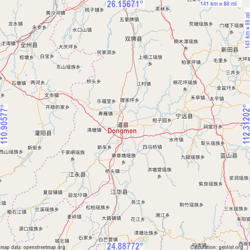
Dongmen GPS coordinates[2]
25° 31' 26.004" North, 111° 36' 32.004" East
| Map corner | latitude | longitude |
|---|---|---|
| Upper-left | 26.15671°, | 110.90577° |
| Center: | 25.52389°, | 111.60889° |
| Lower-right: | 24.88772°, | 112.31202° |
| Map W x H: | 141.1×141.1 km | = 87.7×87.7mi |
| max Lat: | 53.31946° ⇑84.2% North |
| Dongmen: | 25.52389° |
| min Lat: | ⇓15.8% South 18.22056° |
| min Long | Dongmen | max Long |
| 75.07348° | 111.60889° | 134.28917° |
| W 35.5%⇐ | ⇒64.5% E |
Elevation
Elevation of Dongmen is 167 m = 548 ft, and this is 317.8 m = 1043 ft below average elevation for this country.
| Max E: |
5622 m = 18445 ft | 49.8% |
| Avg. | 484.8 m = 1591 ft | |
| Dongmen | 167 m = 548 ft | |
Min E: |
-3 m = -10 ft | 50.2% |
See also: China elevation on elevation.city.
Geographical zone
Dongmen is located in North temperate zone (between Tropic of Cancer and the Arctic Circle). Distance of this Northern Tropic circle is 232.1 km =144.2 mi to South.| Distance of | km | miles | from Dongmen |
|---|---|---|---|
| North Pole | 7169.1 | 4454.7 | to North |
| Arctic Circle | 4563.2 | 2835.4 | to North |
| Tropic Cancer | 232.1 | 144.2 | to South |
| Equator | 2838 | 1763.5 | to South |


Nearby cities:
15 places around Dongmen: (largest is in red/bold)
• Baimadu
8.4 km =5.2 mi,  70°
70°
• Baimangpu
9.4 km =5.8 mi,  83°
83°
• Daojiang
3 km =1.9 mi,  289°
289°
• Daojiang
6.5 km =4 mi,  241°
241°
• Futang
4 km =2.5 mi,  346°
346°
• Hengling
24.1 km =15 mi,  149°
149°
• Lefutang
17.4 km =10.8 mi,  322°
322°
• Qiaotou
26.7 km =16.6 mi,  195°
195°
• Shangjiangxu
26.1 km =16.2 mi,  224°
224°
• Shenzhangtang
18.8 km =11.7 mi,  182°
182°
• Shouyan
11.9 km =7.4 mi,  296°
296°
• Simaqiao
19.4 km =12.1 mi,  128°
128°
• Tiantang
28 km =17.4 mi, 83°
• Wanjiazhuang
4.7 km =2.9 mi,  232°
232°
• Xinche
16.9 km =10.5 mi, 223°
Sources, notices
• [Note1] Compared only with cities in China existing in our database
• [Src1] Map data: © OpenStreetMap contributors (CC-BY-SA)
• [Src2] Other city data from geonames.org with taken over terms of usage.
• [Src3] Geographical zone / Annual Mean Temperature by Robert A. Rohde @ Wikipedia
