Chaoyang geodata
Chaoyang (Shanxi) is a seat of a third-order administrative division; located in China in Asia/Shanghai (GMT+8) time zone. In our database, there are 1268 cities with bigger population. Compared to other cities in China, 80.8% of cities are located further ↓South; 56.6% of cities are located further →East and 86.3% of cities have lower elevation than Chaoyang. Note1


Chaoyang GPS coordinates[2]
37° 54' 28.836" North, 113° 9' 1.584" East
| Map corner | latitude | longitude |
|---|---|---|
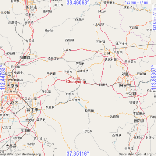
| Upper-left | 38.46068°, | 112.44732° |
| Center: | 37.90801°, | 113.15044° |
| Lower-right: | 37.35116°, | 113.85357° |
| Map W x H: | 123.4×123.4 km | = 76.7×76.7mi |
| max Lat: | 53.31946° ⇑19.2% North |
| Chaoyang: | 37.90801° |
| min Lat: | ⇓80.8% South 18.22056° |
| min Long | Chaoyang | max Long |
| 75.07348° | 113.15044° | 134.28917° |
| W 43.4%⇐ | ⇒56.6% E |
Elevation
Elevation of Chaoyang is 1062 m = 3484 ft, and this is 577.2 m = 1894 ft above average elevation for this country.
| Max E: |
5622 m = 18445 ft | 13.7% |
| Chaoyang | 1062 m 3484 ft | |
| Avg. | 484.8 m = 1591 ft | |
Min E: |
-3 m = -10 ft | 86.3% |
See also: China elevation on elevation.city.
Geographical zone
Chaoyang is located in North temperate zone (between Tropic of Cancer and the Arctic Circle). Distance of this Northern Tropic circle is 1609.1 km =999.8 mi to South.| Distance of | km | miles | from Chaoyang |
|---|---|---|---|
| North Pole | 5792.1 | 3599 | to North |
| Arctic Circle | 3186.2 | 1979.8 | to North |
| Tropic Cancer | 1609.1 | 999.8 | to South |
| Equator | 4215 | 2619.1 | to South |


Nearby cities:
15 places around Chaoyang: (largest is in red/bold)
• Changning
38.9 km =24.2 mi,  223°
223°
• Dongzhao
35.7 km =22.2 mi,  228°
228°
• Guanshan
40.7 km =25.3 mi,  105°
105°
• Huangzhai
46.9 km =29.1 mi,  293°
293°
• Julun
52 km =32.3 mi,  269°
269°
• Leping
55.8 km =34.7 mi,  125°
125°
• Liuxiang
51.9 km =32.2 mi, 265°
• Qianfeng
55.6 km =34.5 mi,  263°
263°
• Taiyuan
52 km =32.3 mi, 265°
• Xiaodian
55.6 km =34.5 mi,  249°
249°
• Xiushui
30.2 km =18.8 mi,  43°
43°
• Yangquan
36.7 km =22.8 mi,  98°
98°
• Yijing
40.4 km =25.1 mi, 101°
• Yinying
35.8 km =22.2 mi,  84°
84°
• Yuci
44.6 km =27.7 mi,  235°
235°
Sources, notices
• [Note1] Compared only with cities in China existing in our database
• [Src1] Map data: © OpenStreetMap contributors (CC-BY-SA)
• [Src2] Other city data from geonames.org with taken over terms of usage.
• [Src3] Geographical zone / Annual Mean Temperature by Robert A. Rohde @ Wikipedia
