Shiyan geodata
Shiyan (Hubei) is a seat of a second-order administrative division; located in China in Asia/Shanghai (GMT+8) time zone. With population of 3,460,000 people, there are 30 cities with bigger population in this country. Compared to other cities in China, 64.6% of cities are located further ↓South; 68% of cities are located further →East and 59% of cities have lower elevation than Shiyan. Note1


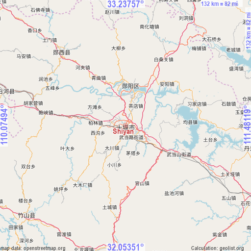
Shiyan GPS coordinates[2]
32° 38' 51" North, 110° 46' 41.016" East
| Map corner | latitude | longitude |
|---|---|---|
| Upper-left | 33.23757°, | 110.07494° |
| Center: | 32.6475°, | 110.77806° |
| Lower-right: | 32.05351°, | 111.48119° |
| Map W x H: | 131.7×131.7 km | = 81.8×81.8mi |
| max Lat: | 53.31946° ⇑35.4% North |
| Shiyan: | 32.6475° |
| min Lat: | ⇓64.6% South 18.22056° |
| min Long | Shiyan | max Long |
| 75.07348° | 110.77806° | 134.28917° |
| W 32%⇐ | ⇒68% E |
Elevation
Elevation of Shiyan is 247 m = 810 ft, and this is 237.8 m = 780 ft below average elevation for this country.
| Max E: |
5622 m = 18445 ft | 41% |
| Avg. | 484.8 m = 1591 ft | |
| Shiyan | 247 m = 810 ft | |
Min E: |
-3 m = -10 ft | 59% |
See also: Shiyan elevation on elevation.city.
Geographical zone
Shiyan is located in North temperate zone (between Tropic of Cancer and the Arctic Circle). Distance of this Northern Tropic circle is 1024.1 km =636.3 mi to South.| Distance of | km | miles | from Shiyan |
|---|---|---|---|
| North Pole | 6377 | 3962.5 | to North |
| Arctic Circle | 3771.1 | 2343.3 | to North |
| Tropic Cancer | 1024.1 | 636.3 | to South |
| Equator | 3630.1 | 2255.6 | to South |


Nearby cities:
15 places around Shiyan: (largest is in red/bold)
• Bailang
13.3 km =8.3 mi,  130°
130°
• Bailin
15.8 km =9.8 mi,  275°
275°
• Chadian
11.9 km =7.4 mi,  27°
27°
• Chechenglu
2.2 km =1.4 mi,  239°
239°
• Dachuan
13.5 km =8.4 mi,  211°
211°
• Eryan
2.9 km =1.8 mi,  184°
184°
• Fangtan
18.6 km =11.6 mi,  302°
302°
• Hanjianglu
3.9 km =2.4 mi,  19°
19°
• Huaguo
9.7 km =6 mi,  266°
266°
• Liubei
17.8 km =11.1 mi,  353°
353°
• Maota
14.7 km =9.1 mi,  164°
164°
• Qingshan
15.7 km =9.8 mi,  53°
53°
• Wudanglu
6.5 km =4 mi, 163°
• Xigou
15.4 km =9.6 mi,  255°
255°
• Yuanyang
11.2 km =7 mi,  121°
121°
Sources, notices
• [Note1] Compared only with cities in China existing in our database
• [Src1] Map data: © OpenStreetMap contributors (CC-BY-SA)
• [Src2] Other city data from geonames.org with taken over terms of usage.
• [Src3] Geographical zone / Annual Mean Temperature by Robert A. Rohde @ Wikipedia
