Fangtan geodata
Fangtan (Hubei) is a seat of a fourth-order administrative division; located in China in Asia/Shanghai (GMT+8) time zone. In our database, there are 1268 cities with bigger population. Compared to other cities in China, 64.9% of cities are located further ↓South; 68.6% of cities are located further →East and 50.8% of cities have higher elevation than Fangtan. Note1


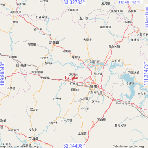
Fangtan GPS coordinates[2]
32° 44' 18.132" North, 110° 36' 41.76" East
| Map corner | latitude | longitude |
|---|---|---|
| Upper-left | 33.32783°, | 109.90848° |
| Center: | 32.73837°, | 110.6116° |
| Lower-right: | 32.14498°, | 111.31473° |
| Map W x H: | 131.5×131.5 km | = 81.7×81.7mi |
| max Lat: | 53.31946° ⇑35.1% North |
| Fangtan: | 32.73837° |
| min Lat: | ⇓64.9% South 18.22056° |
| min Long | Fangtan | max Long |
| 75.07348° | 110.6116° | 134.28917° |
| W 31.4%⇐ | ⇒68.6% E |
Elevation
Elevation of Fangtan is 158 m = 518 ft, and this is 326.8 m = 1072 ft below average elevation for this country.
| Max E: |
5622 m = 18445 ft | 50.8% |
| Avg. | 484.8 m = 1591 ft | |
| Fangtan | 158 m = 518 ft | |
Min E: |
-3 m = -10 ft | 49.2% |
See also: China elevation on elevation.city.
Geographical zone
Fangtan is located in North temperate zone (between Tropic of Cancer and the Arctic Circle). Distance of this Northern Tropic circle is 1034.2 km =642.6 mi to South.| Distance of | km | miles | from Fangtan |
|---|---|---|---|
| North Pole | 6366.9 | 3956.2 | to North |
| Arctic Circle | 3761 | 2337 | to North |
| Tropic Cancer | 1034.2 | 642.6 | to South |
| Equator | 3640.2 | 2261.9 | to South |


Nearby cities:
15 places around Fangtan: (largest is in red/bold)
• Bailin
8.6 km =5.3 mi,  180°
180°
• Chadian
21 km =13 mi,  88°
88°
• Chechenglu
17.7 km =11 mi,  129°
129°
• Dachuan
23.2 km =14.4 mi,  158°
158°
• Eryan
20.1 km =12.5 mi, 130°
• Hanjianglu
18.1 km =11.2 mi,  110°
110°
• Hejia
21.8 km =13.5 mi,  341°
341°
• Huaguo
12.1 km =7.5 mi,  151°
151°
• Huanglong
7.6 km =4.7 mi,  215°
215°
• Liubei
15.5 km =9.6 mi,  60°
60°
• Qingqu
15.5 km =9.6 mi,  5°
5°
• Shiyan
18.6 km =11.6 mi,  122°
122°
• Wudanglu
23.9 km =14.9 mi, 133°
• Xigou
14 km =8.7 mi, 177°
• Yunxian Chengguanzhen
21.1 km =13.1 mi, 60°
Sources, notices
• [Note1] Compared only with cities in China existing in our database
• [Src1] Map data: © OpenStreetMap contributors (CC-BY-SA)
• [Src2] Other city data from geonames.org with taken over terms of usage.
• [Src3] Geographical zone / Annual Mean Temperature by Robert A. Rohde @ Wikipedia
