Shipai geodata
Shipai (Fujian) is a seat of a fourth-order administrative division; located in China in Asia/Shanghai (GMT+8) time zone. In our database, there are 1268 cities with bigger population. Compared to other cities in China, 83.7% of cities are located further ↑North; 70% of cities are located further ←West and 69.6% of cities have lower elevation than Shipai. Note1


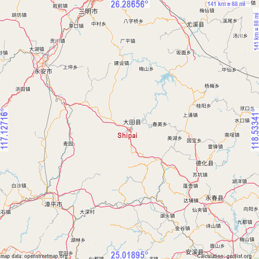
Shipai GPS coordinates[2]
25° 39' 15.984" North, 117° 49' 49.008" East
| Map corner | latitude | longitude |
|---|---|---|
| Upper-left | 26.28656°, | 117.12716° |
| Center: | 25.65444°, | 117.83028° |
| Lower-right: | 25.01895°, | 118.53341° |
| Map W x H: | 140.9×140.9 km | = 87.6×87.6mi |
| max Lat: | 53.31946° ⇑83.7% North |
| Shipai: | 25.65444° |
| min Lat: | ⇓16.3% South 18.22056° |
| min Long | Shipai | max Long |
| 75.07348° | 117.83028° | 134.28917° |
| W 70%⇐ | ⇒30% E |
Elevation
Elevation of Shipai is 403 m = 1322 ft, and this is 81.8 m = 268 ft below average elevation for this country.
| Max E: |
5622 m = 18445 ft | 30.4% |
| Avg. | 484.8 m = 1591 ft | |
| Shipai | 403 m = 1322 ft | |
Min E: |
-3 m = -10 ft | 69.6% |
See also: China elevation on elevation.city.
Geographical zone
Shipai is located in North temperate zone (between Tropic of Cancer and the Arctic Circle). Distance of this Northern Tropic circle is 246.6 km =153.2 mi to South.| Distance of | km | miles | from Shipai |
|---|---|---|---|
| North Pole | 7154.6 | 4445.7 | to North |
| Arctic Circle | 4548.7 | 2826.4 | to North |
| Tropic Cancer | 246.6 | 153.2 | to South |
| Equator | 2852.5 | 1772.5 | to South |


Nearby cities:
15 places around Shipai: (largest is in red/bold)
• Chunmei
16.7 km =10.4 mi,  77°
77°
• Hengkou
22.9 km =14.2 mi,  164°
164°
• Huaxing
7 km =4.3 mi,  52°
52°
• Humei
18.8 km =11.7 mi,  33°
33°
• Jiyang
18.3 km =11.4 mi,  135°
135°
• Junxi
5.1 km =3.2 mi,  17°
17°
• Pingshan
9.3 km =5.8 mi, 137°
• Qianping
21.5 km =13.4 mi,  9°
9°
• Shangjing
18 km =11.2 mi,  294°
294°
• Taihua
21.1 km =13.1 mi,  327°
327°
• Wuci
19.7 km =12.2 mi,  251°
251°
• Wuling
11.8 km =7.3 mi,  257°
257°
• Wushan
14.7 km =9.1 mi,  152°
152°
• Xieyang
13.4 km =8.3 mi,  213°
213°
• Yidu
21.8 km =13.5 mi,  185°
185°
Sources, notices
• [Note1] Compared only with cities in China existing in our database
• [Src1] Map data: © OpenStreetMap contributors (CC-BY-SA)
• [Src2] Other city data from geonames.org with taken over terms of usage.
• [Src3] Geographical zone / Annual Mean Temperature by Robert A. Rohde @ Wikipedia
