Tongchuanshi geodata
Tongchuanshi (Shaanxi) is a populated place; located in China in Asia/Shanghai (GMT+8) time zone. With population of 223,603 people, there are 215 cities with bigger population in this country. Compared to other cities in China, 75.2% of cities are located further ↓South; 75.9% of cities are located further →East and 82.8% of cities have lower elevation than Tongchuanshi. Note1


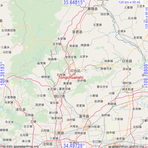
Tongchuanshi GPS coordinates[2]
35° 4' 29.064" North, 109° 5' 5.82" East
| Map corner | latitude | longitude |
|---|---|---|
| Upper-left | 35.64815°, | 108.38183° |
| Center: | 35.07474°, | 109.08495° |
| Lower-right: | 34.49728°, | 109.78808° |
| Map W x H: | 128×128 km | = 79.5×79.5mi |
| max Lat: | 53.31946° ⇑24.8% North |
| Tongchuanshi: | 35.07474° |
| min Lat: | ⇓75.2% South 18.22056° |
| min Long | Tongchuanshi | max Long |
| 75.07348° | 109.08495° | 134.28917° |
| W 24.1%⇐ | ⇒75.9% E |
Elevation
Elevation of Tongchuanshi is 834 m = 2736 ft, and this is 349.2 m = 1146 ft above average elevation for this country.
| Max E: |
5622 m = 18445 ft | 17.2% |
| Tongchuanshi | 834 m 2736 ft | |
| Avg. | 484.8 m = 1591 ft | |
Min E: |
-3 m = -10 ft | 82.8% |
See also: Tongchuanshi elevation on elevation.city.
Geographical zone
Tongchuanshi is located in North temperate zone (between Tropic of Cancer and the Arctic Circle). Distance of this Northern Tropic circle is 1294 km =804.1 mi to South.| Distance of | km | miles | from Tongchuanshi |
|---|---|---|---|
| North Pole | 6107.1 | 3794.8 | to North |
| Arctic Circle | 3501.2 | 2175.5 | to North |
| Tropic Cancer | 1294 | 804.1 | to South |
| Equator | 3899.9 | 2423.3 | to South |


Nearby cities:
15 places around Tongchuanshi: (largest is in red/bold)
• Baimiao
16.1 km =10 mi,  160°
160°
• Caocun
22.1 km =13.7 mi,  151°
151°
• Didian
15.7 km =9.8 mi,  129°
129°
• Dongjiahe
14.8 km =9.2 mi,  212°
212°
• Gongli
27.6 km =17.1 mi,  168°
168°
• Guanzhuang
23.8 km =14.8 mi,  236°
236°
• Huangbao
9.6 km =6 mi, 214°
• Meijiaping
24.7 km =15.3 mi,  199°
199°
• Qicun
28.1 km =17.5 mi,  175°
175°
• Sigou
20.6 km =12.8 mi,  222°
222°
• Sunyuan
15.5 km =9.6 mi, 200°
• Tongchuan
23.1 km =14.4 mi, 212°
• Xiaohui
25 km =15.5 mi,  137°
137°
• Xuezhen
23.4 km =14.5 mi,  124°
124°
• Yaozhou
21.6 km =13.4 mi, 209°
Sources, notices
• [Note1] Compared only with cities in China existing in our database
• [Src1] Map data: © OpenStreetMap contributors (CC-BY-SA)
• [Src2] Other city data from geonames.org with taken over terms of usage.
• [Src3] Geographical zone / Annual Mean Temperature by Robert A. Rohde @ Wikipedia
