Sunyuan geodata
Sunyuan (Shaanxi) is a seat of a fourth-order administrative division; located in China in Asia/Shanghai (GMT+8) time zone. In our database, there are 1268 cities with bigger population. Compared to other cities in China, 74.8% of cities are located further ↓South; 76.2% of cities are located further →East and 82.6% of cities have lower elevation than Sunyuan. Note1


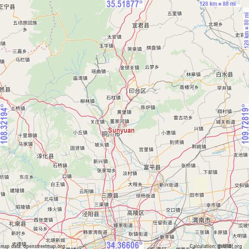
Sunyuan GPS coordinates[2]
34° 56' 39.984" North, 109° 1' 30.216" East
| Map corner | latitude | longitude |
|---|---|---|
| Upper-left | 35.51877°, | 108.32194° |
| Center: | 34.94444°, | 109.02506° |
| Lower-right: | 34.36606°, | 109.72819° |
| Map W x H: | 128.2×128.2 km | = 79.7×79.7mi |
| max Lat: | 53.31946° ⇑25.2% North |
| Sunyuan: | 34.94444° |
| min Lat: | ⇓74.8% South 18.22056° |
| min Long | Sunyuan | max Long |
| 75.07348° | 109.02506° | 134.28917° |
| W 23.8%⇐ | ⇒76.2% E |
Elevation
Elevation of Sunyuan is 825 m = 2707 ft, and this is 340.2 m = 1116 ft above average elevation for this country.
| Max E: |
5622 m = 18445 ft | 17.4% |
| Sunyuan | 825 m 2707 ft | |
| Avg. | 484.8 m = 1591 ft | |
Min E: |
-3 m = -10 ft | 82.6% |
See also: China elevation on elevation.city.
Geographical zone
Sunyuan is located in North temperate zone (between Tropic of Cancer and the Arctic Circle). Distance of this Northern Tropic circle is 1279.5 km =795 mi to South.| Distance of | km | miles | from Sunyuan |
|---|---|---|---|
| North Pole | 6121.6 | 3803.8 | to North |
| Arctic Circle | 3515.7 | 2184.6 | to North |
| Tropic Cancer | 1279.5 | 795 | to South |
| Equator | 3885.5 | 2414.3 | to South |


Nearby cities:
15 places around Sunyuan: (largest is in red/bold)
• Baimiao
10.8 km =6.7 mi,  93°
93°
• Dongjiahe
3.3 km =2.1 mi,  308°
308°
• Gongli
16.6 km =10.3 mi,  139°
139°
• Guanzhuang
14.5 km =9 mi,  275°
275°
• Huangbao
6.6 km =4.1 mi,  359°
359°
• Ma’e
15.9 km =9.9 mi,  212°
212°
• Meijiaping
9.2 km =5.7 mi,  198°
198°
• Mizi
14.7 km =9.1 mi,  183°
183°
• Potou
15.7 km =9.8 mi,  229°
229°
• Qicun
15.6 km =9.7 mi,  150°
150°
• Sigou
8.5 km =5.3 mi,  265°
265°
• Tongchuan
8.5 km =5.3 mi, 233°
• Tongchuanshi
15.5 km =9.6 mi,  20°
20°
• Yaozhou
6.6 km =4.1 mi, 229°
• Zhuangli
14.2 km =8.8 mi,  167°
167°
Sources, notices
• [Note1] Compared only with cities in China existing in our database
• [Src1] Map data: © OpenStreetMap contributors (CC-BY-SA)
• [Src2] Other city data from geonames.org with taken over terms of usage.
• [Src3] Geographical zone / Annual Mean Temperature by Robert A. Rohde @ Wikipedia
