Shihudang geodata
Shihudang (Shanghai) is a seat of a fourth-order administrative division; located in China in Asia/Shanghai (GMT+8) time zone. In our database, there are 1268 cities with bigger population. Compared to other cities in China, 54.7% of cities are located further ↓South; 88.2% of cities are located further ←West and 94.3% of cities have higher elevation than Shihudang. Note1


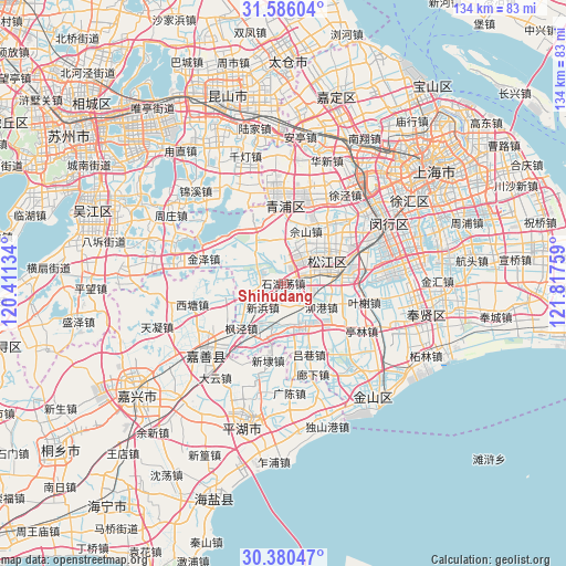
Shihudang GPS coordinates[2]
30° 59' 6.576" North, 121° 6' 52.056" East
| Map corner | latitude | longitude |
|---|---|---|
| Upper-left | 31.58604°, | 120.41134° |
| Center: | 30.98516°, | 121.11446° |
| Lower-right: | 30.38047°, | 121.81759° |
| Map W x H: | 134×134 km | = 83.3×83.3mi |
| max Lat: | 53.31946° ⇑45.3% North |
| Shihudang: | 30.98516° |
| min Lat: | ⇓54.7% South 18.22056° |
| min Long | Shihudang | max Long |
| 75.07348° | 121.11446° | 134.28917° |
| W 88.2%⇐ | ⇒11.8% E |
Elevation
Elevation of Shihudang is 7 m = 23 ft, and this is 477.8 m = 1568 ft below average elevation for this country.
| Max E: |
5622 m = 18445 ft | 94.3% |
| Avg. | 484.8 m = 1591 ft | |
| Shihudang | 7 m = 23 ft | |
Min E: |
-3 m = -10 ft | 5.7% |
See also: China elevation on elevation.city.
Geographical zone
Shihudang is located in North temperate zone (between Tropic of Cancer and the Arctic Circle). Distance of this Northern Tropic circle is 839.3 km =521.5 mi to South.| Distance of | km | miles | from Shihudang |
|---|---|---|---|
| North Pole | 6561.8 | 4077.3 | to North |
| Arctic Circle | 3955.9 | 2458.1 | to North |
| Tropic Cancer | 839.3 | 521.5 | to South |
| Equator | 3445.2 | 2140.7 | to South |


Nearby cities:
15 places around Shihudang: (largest is in red/bold)
• Dingzha
16.2 km =10.1 mi,  273°
273°
• Dongjing
18.1 km =11.2 mi,  51°
51°
• Fangsong
8.9 km =5.5 mi, 53°
• Fengjing
14.4 km =8.9 mi,  222°
222°
• Liantang
7.2 km =4.5 mi,  294°
294°
• Maogang
10.6 km =6.6 mi,  121°
121°
• Sheshan
14.3 km =8.9 mi,  25°
25°
• Songjiang
11.1 km =6.9 mi,  59°
59°
• Xinbang
7.6 km =4.7 mi, 221°
• Yaozhuang
17 km =10.6 mi,  242°
242°
• Yongfeng
8.6 km =5.3 mi,  74°
74°
• Yueyang
10 km =6.2 mi, 74°
• Zhongshan
13.6 km =8.5 mi, 65°
• Zhujiajiao
14.7 km =9.1 mi,  338°
338°
• Zhujing
10.3 km =6.4 mi,  155°
155°
Sources, notices
• [Note1] Compared only with cities in China existing in our database
• [Src1] Map data: © OpenStreetMap contributors (CC-BY-SA)
• [Src2] Other city data from geonames.org with taken over terms of usage.
• [Src3] Geographical zone / Annual Mean Temperature by Robert A. Rohde @ Wikipedia
