Zhujiajiao geodata
Zhujiajiao (Shanghai) is a seat of a fourth-order administrative division; located in China in Asia/Shanghai (GMT+8) time zone. With population of 60,000 people, there are 732 cities with bigger population in this country. Compared to other cities in China, 55.6% of cities are located further ↓South; 88% of cities are located further ←West and 91.2% of cities have higher elevation than Zhujiajiao. Note1


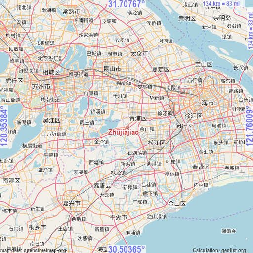
Zhujiajiao GPS coordinates[2]
31° 6' 27.252" North, 121° 3' 25.056" East
| Map corner | latitude | longitude |
|---|---|---|
| Upper-left | 31.70767°, | 120.35384° |
| Center: | 31.10757°, | 121.05696° |
| Lower-right: | 30.50365°, | 121.76009° |
| Map W x H: | 133.9×133.9 km | = 83.2×83.2mi |
| max Lat: | 53.31946° ⇑44.4% North |
| Zhujiajiao: | 31.10757° |
| min Lat: | ⇓55.6% South 18.22056° |
| min Long | Zhujiajiao | max Long |
| 75.07348° | 121.05696° | 134.28917° |
| W 88%⇐ | ⇒12% E |
Elevation
Elevation of Zhujiajiao is 9 m = 30 ft, and this is 475.8 m = 1561 ft below average elevation for this country.
| Max E: |
5622 m = 18445 ft | 91.2% |
| Avg. | 484.8 m = 1591 ft | |
| Zhujiajiao | 9 m = 30 ft | |
Min E: |
-3 m = -10 ft | 8.8% |
See also: Zhujiajiao elevation on elevation.city.
Geographical zone
Zhujiajiao is located in North temperate zone (between Tropic of Cancer and the Arctic Circle). Distance of this Northern Tropic circle is 852.9 km =530 mi to South.| Distance of | km | miles | from Zhujiajiao |
|---|---|---|---|
| North Pole | 6548.2 | 4068.9 | to North |
| Arctic Circle | 3942.3 | 2449.6 | to North |
| Tropic Cancer | 852.9 | 530 | to South |
| Equator | 3458.8 | 2149.2 | to South |


Nearby cities:
15 places around Zhujiajiao: (largest is in red/bold)
• Chonggu
15.2 km =9.4 mi,  45°
45°
• Dianshanhu
9.1 km =5.7 mi,  340°
340°
• Dingzha
16.5 km =10.3 mi,  220°
220°
• Fangsong
15.1 km =9.4 mi,  123°
123°
• Jinxi
17.5 km =10.9 mi,  297°
297°
• Jinze
15.6 km =9.7 mi,  239°
239°
• Liantang
10.7 km =6.6 mi,  185°
185°
• Sheshan
11.7 km =7.3 mi,  93°
93°
• Shihudang
14.7 km =9.1 mi,  158°
158°
• Songjiang
17 km =10.6 mi, 117°
• Xianghuaqiao
9.4 km =5.8 mi,  37°
37°
• Xiayang
7.3 km =4.5 mi, 50°
• Yingpu
7 km =4.3 mi, 41°
• Yongfeng
17.8 km =11.1 mi,  129°
129°
• Zhaoxiang
13.8 km =8.6 mi,  69°
69°
Sources, notices
• [Note1] Compared only with cities in China existing in our database
• [Src1] Map data: © OpenStreetMap contributors (CC-BY-SA)
• [Src2] Other city data from geonames.org with taken over terms of usage.
• [Src3] Geographical zone / Annual Mean Temperature by Robert A. Rohde @ Wikipedia
