Liantang geodata
Liantang (Shanghai) is a seat of a fourth-order administrative division; located in China in Asia/Shanghai (GMT+8) time zone. In our database, there are 1268 cities with bigger population. Compared to other cities in China, 55% of cities are located further ↓South; 88% of cities are located further ←West and 98.3% of cities have higher elevation than Liantang. Note1


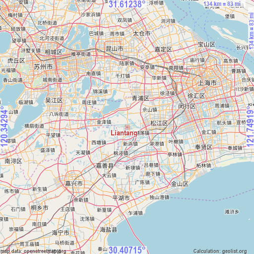
Liantang GPS coordinates[2]
31° 0' 42.012" North, 121° 2' 45.816" East
| Map corner | latitude | longitude |
|---|---|---|
| Upper-left | 31.61238°, | 120.34294° |
| Center: | 31.01167°, | 121.04606° |
| Lower-right: | 30.40715°, | 121.74919° |
| Map W x H: | 134×134 km | = 83.3×83.3mi |
| max Lat: | 53.31946° ⇑45% North |
| Liantang: | 31.01167° |
| min Lat: | ⇓55% South 18.22056° |
| min Long | Liantang | max Long |
| 75.07348° | 121.04606° | 134.28917° |
| W 88%⇐ | ⇒12% E |
Elevation
Elevation of Liantang is 4 m = 13 ft, and this is 480.8 m = 1577 ft below average elevation for this country.
| Max E: |
5622 m = 18445 ft | 98.3% |
| Avg. | 484.8 m = 1591 ft | |
| Liantang | 4 m = 13 ft | |
Min E: |
-3 m = -10 ft | 1.7% |
See also: China elevation on elevation.city.
Geographical zone
Liantang is located in North temperate zone (between Tropic of Cancer and the Arctic Circle). Distance of this Northern Tropic circle is 842.3 km =523.4 mi to South.| Distance of | km | miles | from Liantang |
|---|---|---|---|
| North Pole | 6558.9 | 4075.5 | to North |
| Arctic Circle | 3953 | 2456.3 | to North |
| Tropic Cancer | 842.3 | 523.4 | to South |
| Equator | 3448.2 | 2142.6 | to South |


Nearby cities:
15 places around Liantang: (largest is in red/bold)
• Dingzha
9.9 km =6.2 mi,  258°
258°
• Fangsong
13.9 km =8.6 mi,  80°
80°
• Fengjing
13.9 km =8.6 mi,  193°
193°
• Jinze
12.8 km =8 mi,  282°
282°
• Sheshan
16.1 km =10 mi,  51°
51°
• Shihudang
7.2 km =4.5 mi,  114°
114°
• Songjiang
16.3 km =10.1 mi, 80°
• Xiayang
16.7 km =10.4 mi,  23°
23°
• Xinbang
8.7 km =5.4 mi,  170°
170°
• Xitang
16.7 km =10.4 mi,  244°
244°
• Yaozhuang
13.8 km =8.6 mi,  218°
218°
• Yongfeng
14.8 km =9.2 mi,  92°
92°
• Yueyang
16.1 km =10 mi, 90°
• Zhujiajiao
10.7 km =6.6 mi,  5°
5°
• Zhujing
16.4 km =10.2 mi,  138°
138°
Sources, notices
• [Note1] Compared only with cities in China existing in our database
• [Src1] Map data: © OpenStreetMap contributors (CC-BY-SA)
• [Src2] Other city data from geonames.org with taken over terms of usage.
• [Src3] Geographical zone / Annual Mean Temperature by Robert A. Rohde @ Wikipedia
