Longquan geodata
Longquan (Shanxi) is a seat of a third-order administrative division; located in China in Asia/Shanghai (GMT+8) time zone. In our database, there are 1268 cities with bigger population. Compared to other cities in China, 83.1% of cities are located further ↓South; 61.7% of cities are located further →East and 91.5% of cities have lower elevation than Longquan. Note1


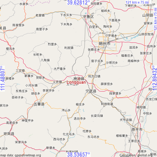
Longquan GPS coordinates[2]
39° 5' 4.056" North, 112° 11' 28.284" East
| Map corner | latitude | longitude |
|---|---|---|
| Upper-left | 39.62812°, | 111.48807° |
| Center: | 39.08446°, | 112.19119° |
| Lower-right: | 38.53657°, | 112.89432° |
| Map W x H: | 121.4×121.4 km | = 75.4×75.4mi |
| max Lat: | 53.31946° ⇑16.9% North |
| Longquan: | 39.08446° |
| min Lat: | ⇓83.1% South 18.22056° |
| min Long | Longquan | max Long |
| 75.07348° | 112.19119° | 134.28917° |
| W 38.3%⇐ | ⇒61.7% E |
Elevation
Elevation of Longquan is 1521 m = 4990 ft, and this is 1036.2 m = 3400 ft above average elevation for this country.
| Max E: |
5622 m = 18445 ft | 8.5% |
| Longquan | 1521 m 4990 ft | |
| Avg. | 484.8 m = 1591 ft | |
Min E: |
-3 m = -10 ft | 91.5% |
See also: China elevation on elevation.city.
Geographical zone
Longquan is located in North temperate zone (between Tropic of Cancer and the Arctic Circle). Distance of this Northern Tropic circle is 1739.9 km =1081.1 mi to South.| Distance of | km | miles | from Longquan |
|---|---|---|---|
| North Pole | 5661.3 | 3517.8 | to North |
| Arctic Circle | 3055.4 | 1898.5 | to North |
| Tropic Cancer | 1739.9 | 1081.1 | to South |
| Equator | 4345.8 | 2700.4 | to South |


Nearby cities:
15 places around Longquan: (largest is in red/bold)
• Bajiao
29.7 km =18.5 mi,  299°
299°
• Dayanbei
16.6 km =10.3 mi, 298°
• Dietaisi
31 km =19.3 mi,  178°
178°
• Donghu
6.8 km =4.2 mi,  278°
278°
• Fenghuang
13.3 km =8.3 mi,  136°
136°
• Hezhi
29.4 km =18.3 mi,  271°
271°
• Hubei
18.2 km =11.3 mi,  238°
238°
• Limin
25.6 km =15.9 mi,  346°
346°
• Shangshaleng
28.6 km =17.8 mi,  63°
63°
• Shangyuzhuang
19.7 km =12.2 mi, 176°
• Taipingzhuang
6.3 km =3.9 mi,  229°
229°
• Xuejiawa
22 km =13.7 mi,  100°
100°
• Yangfangkou
12.2 km =7.6 mi,  81°
81°
• Yijing
16.7 km =10.4 mi,  262°
262°
• Zhangcaizhuang
25.5 km =15.8 mi,  27°
27°
Sources, notices
• [Note1] Compared only with cities in China existing in our database
• [Src1] Map data: © OpenStreetMap contributors (CC-BY-SA)
• [Src2] Other city data from geonames.org with taken over terms of usage.
• [Src3] Geographical zone / Annual Mean Temperature by Robert A. Rohde @ Wikipedia
