Xuejiawa geodata
Xuejiawa (Shanxi) is a seat of a fourth-order administrative division; located in China in Asia/Shanghai (GMT+8) time zone. In our database, there are 1268 cities with bigger population. Compared to other cities in China, 82.9% of cities are located further ↓South; 60.4% of cities are located further →East and 93.3% of cities have lower elevation than Xuejiawa. Note1


Xuejiawa GPS coordinates[2]
39° 2' 59.1" North, 112° 26' 32.82" East
| Map corner | latitude | longitude |
|---|---|---|
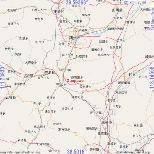
| Upper-left | 39.59368°, | 111.73933° |
| Center: | 39.04975°, | 112.44245° |
| Lower-right: | 38.5016°, | 113.14558° |
| Map W x H: | 121.4×121.4 km | = 75.4×75.4mi |
| max Lat: | 53.31946° ⇑17.1% North |
| Xuejiawa: | 39.04975° |
| min Lat: | ⇓82.9% South 18.22056° |
| min Long | Xuejiawa | max Long |
| 75.07348° | 112.44245° | 134.28917° |
| W 39.6%⇐ | ⇒60.4% E |
Elevation
Elevation of Xuejiawa is 1752 m = 5748 ft, and this is 1267.2 m = 4157 ft above average elevation for this country.
| Max E: |
5622 m = 18445 ft | 6.7% |
| Xuejiawa | 1752 m 5748 ft | |
| Avg. | 484.8 m = 1591 ft | |
Min E: |
-3 m = -10 ft | 93.3% |
See also: China elevation on elevation.city.
Geographical zone
Xuejiawa is located in North temperate zone (between Tropic of Cancer and the Arctic Circle). Distance of this Northern Tropic circle is 1736 km =1078.7 mi to South.| Distance of | km | miles | from Xuejiawa |
|---|---|---|---|
| North Pole | 5665.1 | 3520.1 | to North |
| Arctic Circle | 3059.2 | 1900.9 | to North |
| Tropic Cancer | 1736 | 1078.7 | to South |
| Equator | 4341.9 | 2697.9 | to South |


Nearby cities:
15 places around Xuejiawa: (largest is in red/bold)
• Dietaisi
34.1 km =21.2 mi,  217°
217°
• Donghu
28.9 km =18 mi,  279°
279°
• Fenghuang
13.8 km =8.6 mi,  245°
245°
• Fushanzhuang
27 km =16.8 mi,  35°
35°
• Jiazhuang
22.8 km =14.2 mi,  19°
19°
• Longquan
22 km =13.7 mi, 280°
• Nanyulinxi
27.2 km =16.9 mi,  49°
49°
• Shangshaleng
17 km =10.6 mi,  13°
13°
• Shangyuzhuang
25.9 km =16.1 mi,  232°
232°
• Shuozhou
29.6 km =18.4 mi,  356°
356°
• Taipingzhuang
26.5 km =16.5 mi,  269°
269°
• Xiatuanpu
35 km =21.7 mi,  350°
350°
• Yangfangkou
11.2 km =7 mi,  300°
300°
• Zhangcaizhuang
28.3 km =17.6 mi,  339°
339°
• Zirun
35 km =21.7 mi, 36°
Sources, notices
• [Note1] Compared only with cities in China existing in our database
• [Src1] Map data: © OpenStreetMap contributors (CC-BY-SA)
• [Src2] Other city data from geonames.org with taken over terms of usage.
• [Src3] Geographical zone / Annual Mean Temperature by Robert A. Rohde @ Wikipedia
