Shekou geodata
Shekou (Guangdong) is a seat of a fourth-order administrative division; located in China in Asia/Shanghai (GMT+8) time zone. In our database, there are 1268 cities with bigger population. Compared to other cities in China, 96.4% of cities are located further ↑North; 51.9% of cities are located further →East and 78.3% of cities have higher elevation than Shekou. Note1


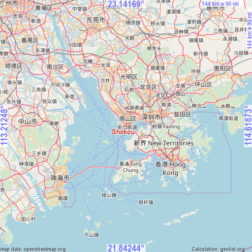
Shekou GPS coordinates[2]
22° 29' 36.924" North, 113° 54' 56.16" East
| Map corner | latitude | longitude |
|---|---|---|
| Upper-left | 23.14169°, | 113.21248° |
| Center: | 22.49359°, | 113.9156° |
| Lower-right: | 21.84244°, | 114.61873° |
| Map W x H: | 144.5×144.5 km | = 89.8×89.8mi |
| max Lat: | 53.31946° ⇑96.4% North |
| Shekou: | 22.49359° |
| min Lat: | ⇓3.6% South 18.22056° |
| min Long | Shekou | max Long |
| 75.07348° | 113.9156° | 134.28917° |
| W 48.1%⇐ | ⇒51.9% E |
Elevation
Elevation of Shekou is 30 m = 98 ft, and this is 454.8 m = 1492 ft below average elevation for this country.
| Max E: |
5622 m = 18445 ft | 78.3% |
| Avg. | 484.8 m = 1591 ft | |
| Shekou | 30 m = 98 ft | |
Min E: |
-3 m = -10 ft | 21.7% |
See also: China elevation on elevation.city.
Geographical zone
Shekou is located in North Torrid zone (between Equator and Tropic of Cancer). Distance of this Northern Tropic circle is 104.9 km =65.2 mi to North.| Distance of | km | miles | from Shekou |
|---|---|---|---|
| North Pole | 7506 | 4664 | to North |
| Arctic Circle | 4900.1 | 3044.8 | to North |
| Tropic Cancer | 104.9 | 65.2 | to North |
| Equator | 2501.1 | 1554.1 | to South |


Nearby cities:
15 places around Shekou: (largest is in red/bold)
• Bantian
21 km =13 mi,  40°
40°
• Dalang
22.6 km =14 mi,  25°
25°
• Fuyong
22.4 km =13.9 mi,  332°
332°
• Haikuotiankong
4.6 km =2.9 mi, 32°
• Longhua
20.6 km =12.8 mi, 27°
• Minzhi
19.2 km =11.9 mi, 40°
• Nanshan
5.5 km =3.4 mi, 25°
• Nantou
4.7 km =2.9 mi,  0°
0°
• Shahe
9.2 km =5.7 mi,  45°
45°
• Shenzhen
16.7 km =10.4 mi,  69°
69°
• Shiyan
21.5 km =13.4 mi,  7°
7°
• Taoyuan
10.7 km =6.6 mi, 25°
• Xili
11 km =6.8 mi,  17°
17°
• Xin’an
8.8 km =5.5 mi, 0°
• Xixiang
11.4 km =7.1 mi,  346°
346°
Sources, notices
• [Note1] Compared only with cities in China existing in our database
• [Src1] Map data: © OpenStreetMap contributors (CC-BY-SA)
• [Src2] Other city data from geonames.org with taken over terms of usage.
• [Src3] Geographical zone / Annual Mean Temperature by Robert A. Rohde @ Wikipedia
