Shanli geodata
Shanli (Anhui) is a seat of a fourth-order administrative division; located in China in Asia/Shanghai (GMT+8) time zone. In our database, there are 1268 cities with bigger population. Compared to other cities in China, 55.4% of cities are located further ↑North; 68.1% of cities are located further ←West and 59.5% of cities have higher elevation than Shanli. Note1


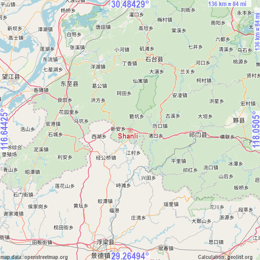
Shanli GPS coordinates[2]
29° 52' 35.328" North, 117° 20' 50.532" East
| Map corner | latitude | longitude |
|---|---|---|
| Upper-left | 30.48429°, | 116.64425° |
| Center: | 29.87648°, | 117.34737° |
| Lower-right: | 29.26494°, | 118.0505° |
| Map W x H: | 135.6×135.6 km | = 84.3×84.3mi |
| max Lat: | 53.31946° ⇑55.4% North |
| Shanli: | 29.87648° |
| min Lat: | ⇓44.6% South 18.22056° |
| min Long | Shanli | max Long |
| 75.07348° | 117.34737° | 134.28917° |
| W 68.1%⇐ | ⇒31.9% E |
Elevation
Elevation of Shanli is 101 m = 331 ft, and this is 383.8 m = 1259 ft below average elevation for this country.
| Max E: |
5622 m = 18445 ft | 59.5% |
| Avg. | 484.8 m = 1591 ft | |
| Shanli | 101 m = 331 ft | |
Min E: |
-3 m = -10 ft | 40.5% |
See also: China elevation on elevation.city.
Geographical zone
Shanli is located in North temperate zone (between Tropic of Cancer and the Arctic Circle). Distance of this Northern Tropic circle is 716 km =444.9 mi to South.| Distance of | km | miles | from Shanli |
|---|---|---|---|
| North Pole | 6685.1 | 4153.9 | to North |
| Arctic Circle | 4079.2 | 2534.7 | to North |
| Tropic Cancer | 716 | 444.9 | to South |
| Equator | 3322 | 2064.2 | to South |


Nearby cities:
15 places around Shanli: (largest is in red/bold)
• Dengta
30.7 km =19.1 mi,  91°
91°
• Guxi
23.4 km =14.5 mi,  70°
70°
• Jiangcun
11.7 km =7.3 mi,  172°
172°
• Jinggongqiao
19.2 km =11.9 mi,  222°
222°
• Likou
15.7 km =9.8 mi,  80°
80°
• Luxi
24.3 km =15.1 mi,  140°
140°
• Makeng
25.9 km =16.1 mi,  281°
281°
• Pingli
29.7 km =18.5 mi,  121°
121°
• Rongkou
23.7 km =14.7 mi,  127°
127°
• Xiaolukou
25.2 km =15.7 mi, 93°
• Xihu
16.5 km =10.3 mi,  259°
259°
• Xin’an
6.6 km =4.1 mi, 280°
• Yangshu
17.4 km =10.8 mi,  63°
63°
• Zhitan
28.7 km =17.8 mi,  187°
187°
• Zhukou
13.4 km =8.3 mi,  100°
100°
Sources, notices
• [Note1] Compared only with cities in China existing in our database
• [Src1] Map data: © OpenStreetMap contributors (CC-BY-SA)
• [Src2] Other city data from geonames.org with taken over terms of usage.
• [Src3] Geographical zone / Annual Mean Temperature by Robert A. Rohde @ Wikipedia
