Dengta geodata
Dengta (Anhui) is a seat of a fourth-order administrative division; located in China in Asia/Shanghai (GMT+8) time zone. In our database, there are 1268 cities with bigger population. Compared to other cities in China, 55.5% of cities are located further ↑North; 69.3% of cities are located further ←West and 50.4% of cities have higher elevation than Dengta. Note1


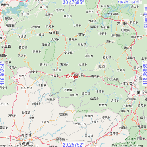
Dengta GPS coordinates[2]
29° 52' 8.76" North, 117° 39' 56.016" East
| Map corner | latitude | longitude |
|---|---|---|
| Upper-left | 30.47695°, | 116.96244° |
| Center: | 29.8691°, | 117.66556° |
| Lower-right: | 29.25752°, | 118.36869° |
| Map W x H: | 135.6×135.6 km | = 84.3×84.3mi |
| max Lat: | 53.31946° ⇑55.5% North |
| Dengta: | 29.8691° |
| min Lat: | ⇓44.5% South 18.22056° |
| min Long | Dengta | max Long |
| 75.07348° | 117.66556° | 134.28917° |
| W 69.3%⇐ | ⇒30.7% E |
Elevation
Elevation of Dengta is 161 m = 528 ft, and this is 323.8 m = 1062 ft below average elevation for this country.
| Max E: |
5622 m = 18445 ft | 50.4% |
| Avg. | 484.8 m = 1591 ft | |
| Dengta | 161 m = 528 ft | |
Min E: |
-3 m = -10 ft | 49.6% |
See also: China elevation on elevation.city.
Geographical zone
Dengta is located in North temperate zone (between Tropic of Cancer and the Arctic Circle). Distance of this Northern Tropic circle is 715.2 km =444.4 mi to South.| Distance of | km | miles | from Dengta |
|---|---|---|---|
| North Pole | 6685.9 | 4154.4 | to North |
| Arctic Circle | 4080 | 2535.2 | to North |
| Tropic Cancer | 715.2 | 444.4 | to South |
| Equator | 3321.1 | 2063.6 | to South |


Nearby cities:
15 places around Dengta: (largest is in red/bold)
• Baixi
13.1 km =8.1 mi,  74°
74°
• Datan
11.8 km =7.3 mi,  44°
44°
• Guxi
12.3 km =7.6 mi,  315°
315°
• Jinzipai
13.9 km =8.6 mi,  100°
100°
• Likou
15.6 km =9.7 mi,  283°
283°
• Pingli
15.7 km =9.8 mi,  200°
200°
• Qiaoshan
12.8 km =8 mi,  156°
156°
• Qihong
19.3 km =12 mi,  179°
179°
• Qishan
5.9 km =3.7 mi,  117°
117°
• Rongkou
18.3 km =11.4 mi,  221°
221°
• Tafang
9.8 km =6.1 mi, 180°
• Xiaolukou
5.6 km =3.5 mi,  261°
261°
• Xuling
6.2 km =3.9 mi, 65°
• Yangshu
17.3 km =10.7 mi,  299°
299°
• Zhukou
17.6 km =10.9 mi, 264°
Sources, notices
• [Note1] Compared only with cities in China existing in our database
• [Src1] Map data: © OpenStreetMap contributors (CC-BY-SA)
• [Src2] Other city data from geonames.org with taken over terms of usage.
• [Src3] Geographical zone / Annual Mean Temperature by Robert A. Rohde @ Wikipedia
