Shanhou geodata
Shanhou (Anhui) is a seat of a fourth-order administrative division; located in China in Asia/Shanghai (GMT+8) time zone. In our database, there are 1268 cities with bigger population. Compared to other cities in China, 60.5% of cities are located further ↓South; 71.3% of cities are located further ←West and 83.4% of cities have higher elevation than Shanhou. Note1


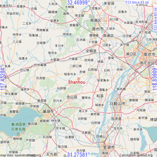
Shanhou GPS coordinates[2]
31° 52' 29.388" North, 118° 9' 21.456" East
| Map corner | latitude | longitude |
|---|---|---|
| Upper-left | 32.46999°, | 117.45284° |
| Center: | 31.87483°, | 118.15596° |
| Lower-right: | 31.27581°, | 118.85909° |
| Map W x H: | 132.8×132.8 km | = 82.5×82.5mi |
| max Lat: | 53.31946° ⇑39.5% North |
| Shanhou: | 31.87483° |
| min Lat: | ⇓60.5% South 18.22056° |
| min Long | Shanhou | max Long |
| 75.07348° | 118.15596° | 134.28917° |
| W 71.3%⇐ | ⇒28.7% E |
Elevation
Elevation of Shanhou is 19 m = 62 ft, and this is 465.8 m = 1528 ft below average elevation for this country.
| Max E: |
5622 m = 18445 ft | 83.4% |
| Avg. | 484.8 m = 1591 ft | |
| Shanhou | 19 m = 62 ft | |
Min E: |
-3 m = -10 ft | 16.6% |
See also: China elevation on elevation.city.
Geographical zone
Shanhou is located in North temperate zone (between Tropic of Cancer and the Arctic Circle). Distance of this Northern Tropic circle is 938.2 km =583 mi to South.| Distance of | km | miles | from Shanhou |
|---|---|---|---|
| North Pole | 6462.9 | 4015.9 | to North |
| Arctic Circle | 3857 | 2396.6 | to North |
| Tropic Cancer | 938.2 | 583 | to South |
| Equator | 3544.1 | 2202.2 | to South |


Nearby cities:
15 places around Shanhou: (largest is in red/bold)
• Chengjia
8 km =5 mi,  300°
300°
• Chengnan
28.4 km =17.6 mi,  141°
141°
• Erlangkou
10.9 km =6.8 mi,  345°
345°
• Huanfeng
18.4 km =11.4 mi,  196°
196°
• Lianhe
30.5 km =19 mi,  150°
150°
• Liyang
25.8 km =16 mi,  132°
132°
• Shiqiao
25.6 km =15.9 mi,  74°
74°
• Shiyang
14 km =8.7 mi,  53°
53°
• Taochang
31 km =19.3 mi,  185°
185°
• Wujiang
28.9 km =18 mi,  91°
91°
• Xiangquan
15.3 km =9.5 mi, 91°
• Xianzong
16.2 km =10.1 mi,  239°
239°
• Xibu
16.2 km =10.1 mi, 131°
• Xiexiang
11.8 km =7.3 mi, 241°
• Zhangjiaji
20.9 km =13 mi, 93°
Sources, notices
• [Note1] Compared only with cities in China existing in our database
• [Src1] Map data: © OpenStreetMap contributors (CC-BY-SA)
• [Src2] Other city data from geonames.org with taken over terms of usage.
• [Src3] Geographical zone / Annual Mean Temperature by Robert A. Rohde @ Wikipedia
